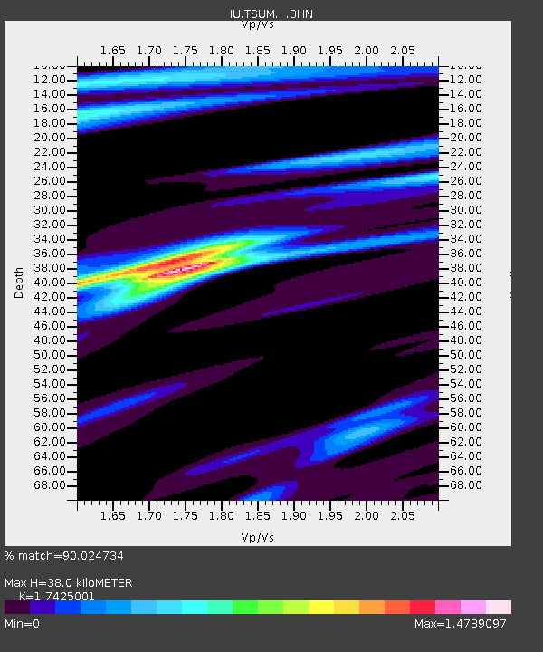
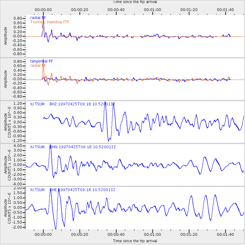
TSUM Tsumeb, Namibia - Earthquake Result Viewer

Earthquake location: Southern Mid-Atlantic Ridge
Earthquake latitude/longitude: -48.3/-10.0
Earthquake time(UTC): 1997/04/25 (115) 09:11:34 GMT
Earthquake Depth: 10 km
Earthquake Magnitude: 5.8 MS, 5.3 MB, 5.8 UNKNOWN, 5.7 MW
Earthquake Catalog/Contributor: WHDF/NEIC
Network: IU Global Seismograph Network (GSN - IRIS/USGS)
Station: TSUM Tsumeb, Namibia
Lat/Lon: 19.20 S/17.58 E
Elevation: 1240 m
Distance: 36.7 deg
Az: 47.211 deg
Baz: 211.204 deg
Ray Param: 0.07655873
Estimated Moho Depth: 38.0 km
Estimated Crust Vp/Vs: 1.74
Assumed Crust Vp: 6.51 km/s
Estimated Crust Vs: 3.736 km/s
Estimated Crust Poisson's Ratio: 0.25
Radial Match: 90.024734 %
Radial Bump: 306
Transverse Match: 72.950806 %
Transverse Bump: 400
SOD ConfigId: 4480
Insert Time: 2010-03-04 15:34:36.034 +0000
GWidth: 2.5
Max Bumps: 400
Tol: 0.001

Signal To Noise

ChannelStoNSTALTA
IU:TSUM: :BHN:19970425T09:18:10.520013Z7.9800591.726024E-62.1629214E-7
IU:TSUM: :BHE:19970425T09:18:10.520013Z4.44364367.65106E-71.7217988E-7
IU:TSUM: :BHZ:19970425T09:18:10.520013Z2.64274455.399928E-72.043303E-7
Arrivals
Ps4.7 SECOND
PpPs15 SECOND
PsPs/PpSs19 SECOND