You are here: Home > Network List > TA - USArray Transportable Network (new EarthScope stations) Stations List
> Station J20K Nowitna River, AK, USA > Earthquake Result Viewer
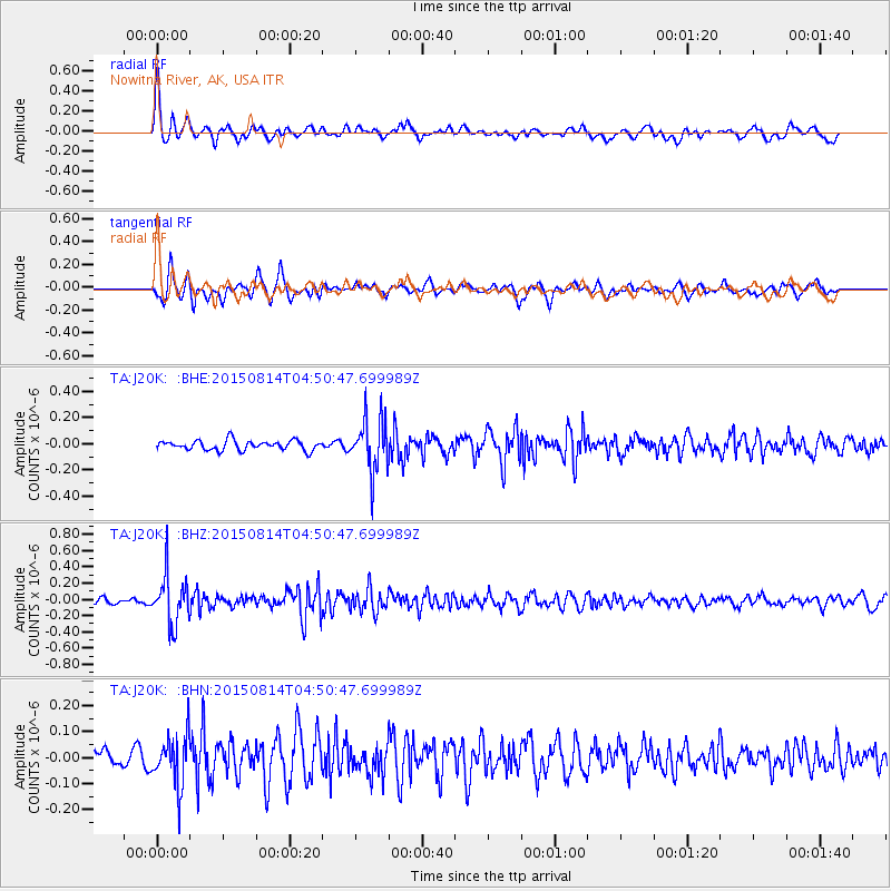
J20K Nowitna River, AK, USA - Earthquake Result Viewer
*The percent match for this event was below the threshold and hence no stack was calculated.
| Earthquake location: |
Hokkaido, Japan Region |
| Earthquake latitude/longitude: |
42.8/143.1 |
| Earthquake time(UTC): |
2015/08/14 (226) 04:43:44 GMT |
| Earthquake Depth: |
85 km |
| Earthquake Magnitude: |
5.2 MW |
| Earthquake Catalog/Contributor: |
ISC/ISC |
|
| Network: |
TA USArray Transportable Network (new EarthScope stations) |
| Station: |
J20K Nowitna River, AK, USA |
| Lat/Lon: |
64.18 N/154.15 W |
| Elevation: |
314 m |
|
| Distance: |
40.9 deg |
| Az: |
36.496 deg |
| Baz: |
269.371 deg |
| Ray Param: |
$rayparam |
*The percent match for this event was below the threshold and hence was not used in the summary stack. |
|
| Radial Match: |
76.46533 % |
| Radial Bump: |
400 |
| Transverse Match: |
73.78494 % |
| Transverse Bump: |
400 |
| SOD ConfigId: |
7422571 |
| Insert Time: |
2019-04-20 09:42:16.705 +0000 |
| GWidth: |
2.5 |
| Max Bumps: |
400 |
| Tol: |
0.001 |
|
Signal To Noise
| Channel | StoN | STA | LTA |
| TA:J20K: :BHZ:20150814T04:50:47.699989Z | 7.614151 | 3.0397916E-7 | 3.9922924E-8 |
| TA:J20K: :BHN:20150814T04:50:47.699989Z | 2.8815944 | 9.6406886E-8 | 3.3456093E-8 |
| TA:J20K: :BHE:20150814T04:50:47.699989Z | 5.6000314 | 2.0610717E-7 | 3.6804646E-8 |
| Arrivals |
| Ps | |
| PpPs | |
| PsPs/PpSs | |


