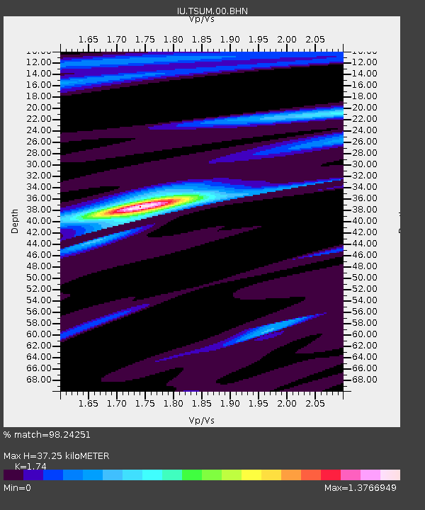
TSUM Tsumeb, Namibia - Earthquake Result Viewer
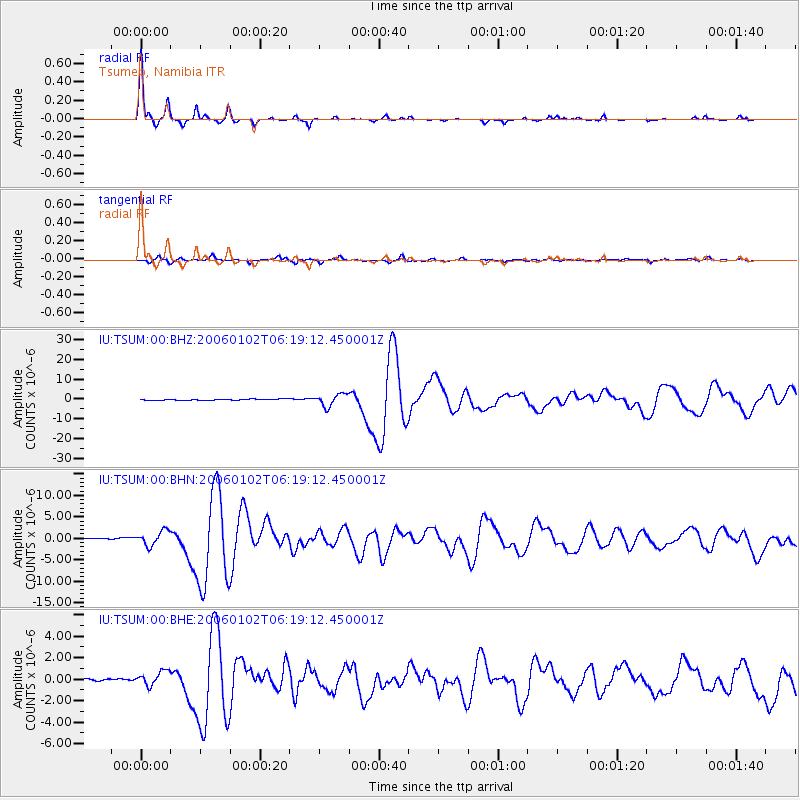
Earthquake location: Southwestern Atlantic Ocean
Earthquake latitude/longitude: -60.9/-21.6
Earthquake time(UTC): 2006/01/02 (002) 06:10:49 GMT
Earthquake Depth: 10 km
Earthquake Magnitude: 6.4 MB, 7.3 MS, 7.4 MW, 7.1 MW
Earthquake Catalog/Contributor: WHDF/NEIC
Network: IU Global Seismograph Network (GSN - IRIS/USGS)
Station: TSUM Tsumeb, Namibia
Lat/Lon: 19.20 S/17.58 E
Elevation: 1240 m
Distance: 50.0 deg
Az: 51.199 deg
Baz: 203.746 deg
Ray Param: 0.06835973
Estimated Moho Depth: 37.25 km
Estimated Crust Vp/Vs: 1.74
Assumed Crust Vp: 6.51 km/s
Estimated Crust Vs: 3.742 km/s
Estimated Crust Poisson's Ratio: 0.25
Radial Match: 98.24251 %
Radial Bump: 160
Transverse Match: 88.232834 %
Transverse Bump: 400
SOD ConfigId: 4977
Insert Time: 2010-03-04 15:35:01.192 +0000
GWidth: 2.5
Max Bumps: 400
Tol: 0.001

Signal To Noise

ChannelStoNSTALTA
IU:TSUM:00:BHN:20060102T06:19:12.450001Z7.9285661.7231704E-62.1733696E-7
IU:TSUM:00:BHE:20060102T06:19:12.450001Z2.84975847.0181335E-72.4627118E-7
IU:TSUM:00:BHZ:20060102T06:19:12.450001Z11.6344693.1006105E-62.665021E-7
Arrivals
Ps4.5 SECOND
PpPs15 SECOND
PsPs/PpSs19 SECOND