You are here: Home > Network List > US - United States National Seismic Network Stations List
> Station LAO LASA Array, Montana, USA > Earthquake Result Viewer
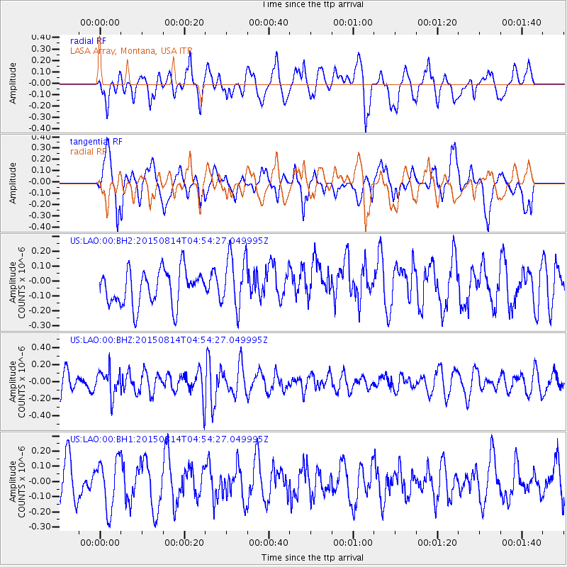
LAO LASA Array, Montana, USA - Earthquake Result Viewer
*The percent match for this event was below the threshold and hence no stack was calculated.
| Earthquake location: |
Hokkaido, Japan Region |
| Earthquake latitude/longitude: |
42.8/143.1 |
| Earthquake time(UTC): |
2015/08/14 (226) 04:43:44 GMT |
| Earthquake Depth: |
85 km |
| Earthquake Magnitude: |
5.2 MW |
| Earthquake Catalog/Contributor: |
ISC/ISC |
|
| Network: |
US United States National Seismic Network |
| Station: |
LAO LASA Array, Montana, USA |
| Lat/Lon: |
46.69 N/106.22 W |
| Elevation: |
902 m |
|
| Distance: |
71.8 deg |
| Az: |
42.699 deg |
| Baz: |
313.501 deg |
| Ray Param: |
$rayparam |
*The percent match for this event was below the threshold and hence was not used in the summary stack. |
|
| Radial Match: |
53.70987 % |
| Radial Bump: |
400 |
| Transverse Match: |
56.81877 % |
| Transverse Bump: |
400 |
| SOD ConfigId: |
7422571 |
| Insert Time: |
2019-04-20 09:43:20.619 +0000 |
| GWidth: |
2.5 |
| Max Bumps: |
400 |
| Tol: |
0.001 |
|
Signal To Noise
| Channel | StoN | STA | LTA |
| US:LAO:00:BHZ:20150814T04:54:27.049995Z | 1.4276085 | 1.518534E-7 | 1.0636907E-7 |
| US:LAO:00:BH1:20150814T04:54:27.049995Z | 1.234304 | 1.6533237E-7 | 1.3394785E-7 |
| US:LAO:00:BH2:20150814T04:54:27.049995Z | 1.5673418 | 1.852789E-7 | 1.1821219E-7 |
| Arrivals |
| Ps | |
| PpPs | |
| PsPs/PpSs | |


