You are here: Home > Network List > IU - Global Seismograph Network (GSN - IRIS/USGS) Stations List
> Station TSUM Tsumeb, Namibia > Earthquake Result Viewer
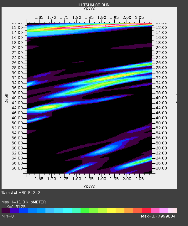
TSUM Tsumeb, Namibia - Earthquake Result Viewer
| Earthquake location: |
South Of Australia |
| Earthquake latitude/longitude: |
-42.8/124.7 |
| Earthquake time(UTC): |
2001/12/12 (346) 14:02:35 GMT |
| Earthquake Depth: |
10 km |
| Earthquake Magnitude: |
6.5 MB, 6.7 MS, 7.1 MW, 7.0 MW |
| Earthquake Catalog/Contributor: |
WHDF/NEIC |
|
| Network: |
IU Global Seismograph Network (GSN - IRIS/USGS) |
| Station: |
TSUM Tsumeb, Namibia |
| Lat/Lon: |
19.20 S/17.58 E |
| Elevation: |
1240 m |
|
| Distance: |
89.0 deg |
| Az: |
244.605 deg |
| Baz: |
135.299 deg |
| Ray Param: |
0.042144563 |
| Estimated Moho Depth: |
11.0 km |
| Estimated Crust Vp/Vs: |
1.91 |
| Assumed Crust Vp: |
6.51 km/s |
| Estimated Crust Vs: |
3.404 km/s |
| Estimated Crust Poisson's Ratio: |
0.31 |
|
| Radial Match: |
89.84343 % |
| Radial Bump: |
400 |
| Transverse Match: |
82.17788 % |
| Transverse Bump: |
400 |
| SOD ConfigId: |
20082 |
| Insert Time: |
2010-03-04 15:35:27.876 +0000 |
| GWidth: |
2.5 |
| Max Bumps: |
400 |
| Tol: |
0.001 |
|

Signal To Noise
| Channel | StoN | STA | LTA |
| IU:TSUM:00:BHN:20011212T14:14:58.570029Z | 1.0323547 | 1.9519945E-7 | 1.8908175E-7 |
| IU:TSUM:00:BHE:20011212T14:14:58.570029Z | 1.0554023 | 2.8500935E-7 | 2.7004808E-7 |
| IU:TSUM:00:BHZ:20011212T14:14:58.570029Z | 0.62811315 | 2.2128299E-7 | 3.5229797E-7 |
| Arrivals |
| Ps | 1.6 SECOND |
| PpPs | 4.8 SECOND |
| PsPs/PpSs | 6.4 SECOND |


