You are here: Home > Network List > GS - US Geological Survey Networks Stations List
> Station KAN13 Rinehart Farm, , CA, USA > Earthquake Result Viewer
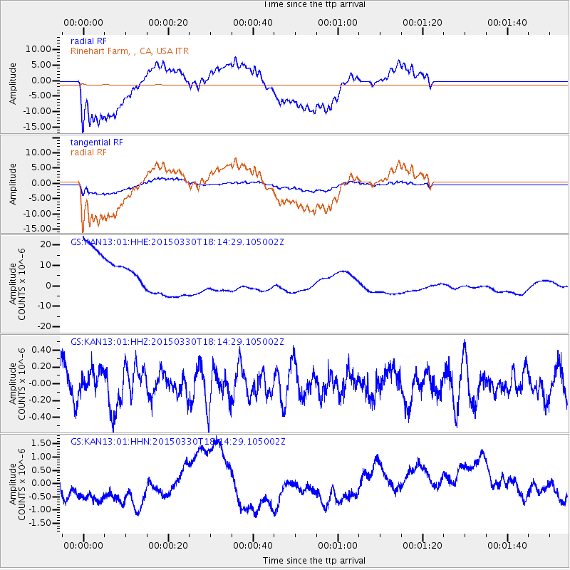
KAN13 Rinehart Farm, , CA, USA - Earthquake Result Viewer
*The percent match for this event was below the threshold and hence no stack was calculated.
| Earthquake location: |
Samoa Islands Region |
| Earthquake latitude/longitude: |
-15.4/-172.9 |
| Earthquake time(UTC): |
2015/03/30 (089) 18:02:10 GMT |
| Earthquake Depth: |
9.6 km |
| Earthquake Magnitude: |
5.8 MWW, 5.7 MWB, 5.8 MWC |
| Earthquake Catalog/Contributor: |
NEIC PDE/NEIC COMCAT |
|
| Network: |
GS US Geological Survey Networks |
| Station: |
KAN13 Rinehart Farm, , CA, USA |
| Lat/Lon: |
37.01 N/97.48 W |
| Elevation: |
340 m |
|
| Distance: |
87.9 deg |
| Az: |
50.81 deg |
| Baz: |
249.042 deg |
| Ray Param: |
$rayparam |
*The percent match for this event was below the threshold and hence was not used in the summary stack. |
|
| Radial Match: |
48.43409 % |
| Radial Bump: |
400 |
| Transverse Match: |
45.30657 % |
| Transverse Bump: |
400 |
| SOD ConfigId: |
872571 |
| Insert Time: |
2015-05-04 18:38:49.826 +0000 |
| GWidth: |
2.5 |
| Max Bumps: |
400 |
| Tol: |
0.001 |
|
Signal To Noise
| Channel | StoN | STA | LTA |
| GS:KAN13:01:HHZ:20150330T18:14:29.105002Z | 0.74883455 | 1.3971346E-7 | 1.8657454E-7 |
| GS:KAN13:01:HHN:20150330T18:14:29.105002Z | 1.307463 | 1.5650301E-6 | 1.1969976E-6 |
| GS:KAN13:01:HHE:20150330T18:14:29.105002Z | 0.7780383 | 7.1727195E-6 | 9.21898E-6 |
| Arrivals |
| Ps | |
| PpPs | |
| PsPs/PpSs | |


