You are here: Home > Network List > IU - Global Seismograph Network (GSN - IRIS/USGS) Stations List
> Station TSUM Tsumeb, Namibia > Earthquake Result Viewer
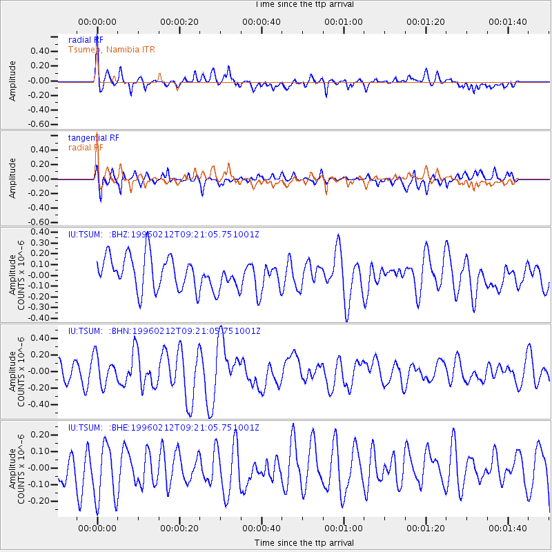
TSUM Tsumeb, Namibia - Earthquake Result Viewer
*The percent match for this event was below the threshold and hence no stack was calculated.
| Earthquake location: |
South Of Sumbawa, Indonesia |
| Earthquake latitude/longitude: |
-11.2/118.7 |
| Earthquake time(UTC): |
1996/02/12 (043) 09:08:10 GMT |
| Earthquake Depth: |
33 km |
| Earthquake Magnitude: |
5.8 MB, 5.8 MS, 6.1 UNKNOWN, 6.0 MW |
| Earthquake Catalog/Contributor: |
WHDF/NEIC |
|
| Network: |
IU Global Seismograph Network (GSN - IRIS/USGS) |
| Station: |
TSUM Tsumeb, Namibia |
| Lat/Lon: |
19.20 S/17.58 E |
| Elevation: |
1240 m |
|
| Distance: |
96.6 deg |
| Az: |
249.014 deg |
| Baz: |
104.181 deg |
| Ray Param: |
$rayparam |
*The percent match for this event was below the threshold and hence was not used in the summary stack. |
|
| Radial Match: |
60.083336 % |
| Radial Bump: |
400 |
| Transverse Match: |
66.68557 % |
| Transverse Bump: |
400 |
| SOD ConfigId: |
4480 |
| Insert Time: |
2010-03-04 15:36:06.984 +0000 |
| GWidth: |
2.5 |
| Max Bumps: |
400 |
| Tol: |
0.001 |
|
Signal To Noise
| Channel | StoN | STA | LTA |
| IU:TSUM: :BHN:19960212T09:21:05.751001Z | 1.0240693 | 1.7072439E-7 | 1.6671176E-7 |
| IU:TSUM: :BHE:19960212T09:21:05.751001Z | 1.8684812 | 1.8550035E-7 | 9.9278694E-8 |
| IU:TSUM: :BHZ:19960212T09:21:05.751001Z | 0.89266676 | 1.408209E-7 | 1.5775305E-7 |
| Arrivals |
| Ps | |
| PpPs | |
| PsPs/PpSs | |


