You are here: Home > Network List > NN - Western Great Basin/Eastern Sierra Nevada Stations List
> Station PAH Pah Rah Range, Nevada w84gm > Earthquake Result Viewer
PAH Pah Rah Range, Nevada w84gm - Earthquake Result Viewer
| Earthquake location: |
Kermadec Islands Region |
| Earthquake latitude/longitude: |
-27.3/-176.0 |
| Earthquake time(UTC): |
2015/08/14 (226) 13:28:00 GMT |
| Earthquake Depth: |
13 km |
| Earthquake Magnitude: |
5.6 MB |
| Earthquake Catalog/Contributor: |
NEIC PDE/NEIC COMCAT |
|
| Network: |
NN Western Great Basin/Eastern Sierra Nevada |
| Station: |
PAH Pah Rah Range, Nevada w84gm |
| Lat/Lon: |
39.71 N/119.39 W |
| Elevation: |
1520 m |
|
| Distance: |
85.0 deg |
| Az: |
40.303 deg |
| Baz: |
228.25 deg |
| Ray Param: |
0.045057923 |
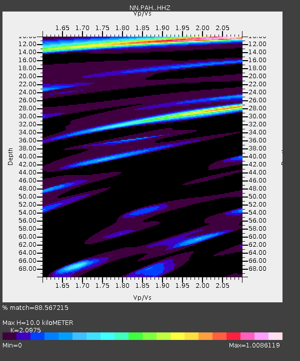
| Estimated Moho Depth: |
10.0 km |
| Estimated Crust Vp/Vs: |
2.10 |
| Assumed Crust Vp: |
6.279 km/s |
| Estimated Crust Vs: |
2.993 km/s |
| Estimated Crust Poisson's Ratio: |
0.35 |
|
| Radial Match: |
88.567215 % |
| Radial Bump: |
400 |
| Transverse Match: |
70.24893 % |
| Transverse Bump: |
400 |
| SOD ConfigId: |
7422571 |
| Insert Time: |
2019-04-20 09:51:58.535 +0000 |
| GWidth: |
2.5 |
| Max Bumps: |
400 |
| Tol: |
0.001 |
|

Signal To Noise
| Channel | StoN | STA | LTA |
| NN:PAH: :HHZ:20150814T13:40:05.185Z | 1.7254497 | 8.745433E-8 | 5.068495E-8 |
| NN:PAH: :HHN:20150814T13:40:05.185Z | 1.100155 | 4.3496566E-8 | 3.953676E-8 |
| NN:PAH: :HHE:20150814T13:40:05.185Z | 0.82821333 | 3.6431263E-8 | 4.3987775E-8 |
| Arrivals |
| Ps | 1.8 SECOND |
| PpPs | 4.8 SECOND |
| PsPs/PpSs | 6.6 SECOND |


