You are here: Home > Network List > UW - Pacific Northwest Regional Seismic Network Stations List
> Station HOOD Mt Hood Meadows, OR CREST BB SMO > Earthquake Result Viewer
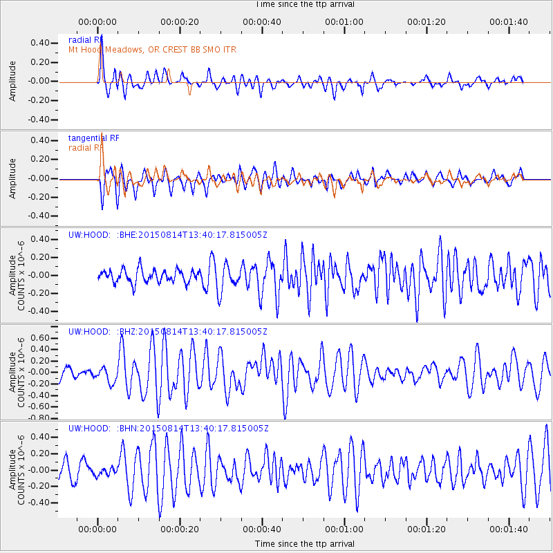
HOOD Mt Hood Meadows, OR CREST BB SMO - Earthquake Result Viewer
*The percent match for this event was below the threshold and hence no stack was calculated.
| Earthquake location: |
Kermadec Islands Region |
| Earthquake latitude/longitude: |
-27.3/-176.0 |
| Earthquake time(UTC): |
2015/08/14 (226) 13:28:00 GMT |
| Earthquake Depth: |
13 km |
| Earthquake Magnitude: |
5.6 MB |
| Earthquake Catalog/Contributor: |
NEIC PDE/NEIC COMCAT |
|
| Network: |
UW Pacific Northwest Regional Seismic Network |
| Station: |
HOOD Mt Hood Meadows, OR CREST BB SMO |
| Lat/Lon: |
45.32 N/121.65 W |
| Elevation: |
1520 m |
|
| Distance: |
87.6 deg |
| Az: |
35.033 deg |
| Baz: |
226.381 deg |
| Ray Param: |
$rayparam |
*The percent match for this event was below the threshold and hence was not used in the summary stack. |
|
| Radial Match: |
77.57763 % |
| Radial Bump: |
400 |
| Transverse Match: |
75.42683 % |
| Transverse Bump: |
400 |
| SOD ConfigId: |
7422571 |
| Insert Time: |
2019-04-20 09:54:09.937 +0000 |
| GWidth: |
2.5 |
| Max Bumps: |
400 |
| Tol: |
0.001 |
|
Signal To Noise
| Channel | StoN | STA | LTA |
| UW:HOOD: :BHZ:20150814T13:40:17.815005Z | 1.6399405 | 1.3182418E-7 | 8.0383515E-8 |
| UW:HOOD: :BHN:20150814T13:40:17.815005Z | 0.5307033 | 4.5399567E-8 | 8.554604E-8 |
| UW:HOOD: :BHE:20150814T13:40:17.815005Z | 2.2232575 | 1.5733298E-7 | 7.076687E-8 |
| Arrivals |
| Ps | |
| PpPs | |
| PsPs/PpSs | |


