You are here: Home > Network List > IU - Global Seismograph Network (GSN - IRIS/USGS) Stations List
> Station TSUM Tsumeb, Namibia > Earthquake Result Viewer
TSUM Tsumeb, Namibia - Earthquake Result Viewer
*The percent match for this event was below the threshold and hence no stack was calculated.
| Earthquake location: |
Myanmar |
| Earthquake latitude/longitude: |
19.3/95.0 |
| Earthquake time(UTC): |
1996/11/11 (316) 09:22:27 GMT |
| Earthquake Depth: |
80 km |
| Earthquake Magnitude: |
5.6 MB, 5.4 MS, 6.0 UNKNOWN, 5.9 MW |
| Earthquake Catalog/Contributor: |
WHDF/NEIC |
|
| Network: |
IU Global Seismograph Network (GSN - IRIS/USGS) |
| Station: |
TSUM Tsumeb, Namibia |
| Lat/Lon: |
19.20 S/17.58 E |
| Elevation: |
1240 m |
|
| Distance: |
85.0 deg |
| Az: |
247.801 deg |
| Baz: |
67.693 deg |
| Ray Param: |
$rayparam |
*The percent match for this event was below the threshold and hence was not used in the summary stack. |
|
| Radial Match: |
49.873016 % |
| Radial Bump: |
400 |
| Transverse Match: |
70.02987 % |
| Transverse Bump: |
400 |
| SOD ConfigId: |
4480 |
| Insert Time: |
2010-03-04 15:36:49.633 +0000 |
| GWidth: |
2.5 |
| Max Bumps: |
400 |
| Tol: |
0.001 |
|
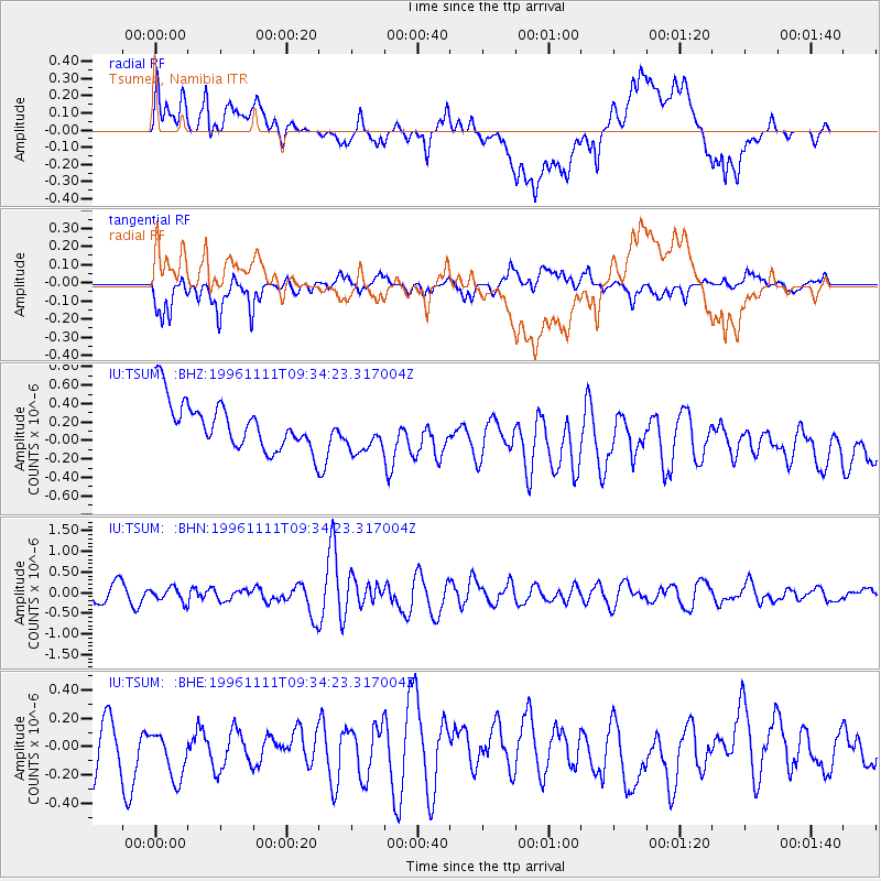
Signal To Noise
| Channel | StoN | STA | LTA |
| IU:TSUM: :BHN:19961111T09:34:23.317004Z | 0.9640529 | 1.6451119E-7 | 1.706454E-7 |
| IU:TSUM: :BHE:19961111T09:34:23.317004Z | 1.2913198 | 2.5185295E-7 | 1.9503531E-7 |
| IU:TSUM: :BHZ:19961111T09:34:23.317004Z | 0.9226761 | 2.3299275E-7 | 2.5251845E-7 |
| Arrivals |
| Ps | |
| PpPs | |
| PsPs/PpSs | |


