You are here: Home > Network List > GS - US Geological Survey Networks Stations List
> Station KAN13 Rinehart Farm > Earthquake Result Viewer
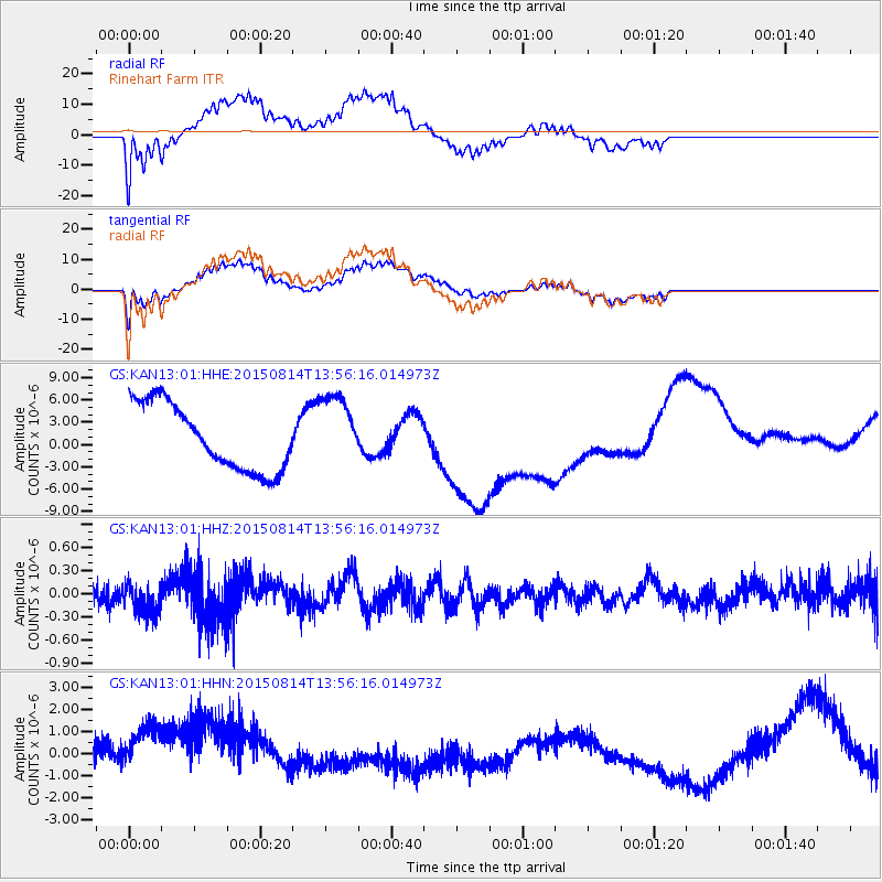
KAN13 Rinehart Farm - Earthquake Result Viewer
*The percent match for this event was below the threshold and hence no stack was calculated.
| Earthquake location: |
Kermadec Islands Region |
| Earthquake latitude/longitude: |
-27.3/-176.2 |
| Earthquake time(UTC): |
2015/08/14 (226) 13:43:16 GMT |
| Earthquake Depth: |
33 km |
| Earthquake Magnitude: |
5.1 MW |
| Earthquake Catalog/Contributor: |
ISC/ISC |
|
| Network: |
GS US Geological Survey Networks |
| Station: |
KAN13 Rinehart Farm |
| Lat/Lon: |
37.01 N/97.48 W |
| Elevation: |
340 m |
|
| Distance: |
97.7 deg |
| Az: |
52.365 deg |
| Baz: |
241.715 deg |
| Ray Param: |
$rayparam |
*The percent match for this event was below the threshold and hence was not used in the summary stack. |
|
| Radial Match: |
62.881065 % |
| Radial Bump: |
400 |
| Transverse Match: |
67.90049 % |
| Transverse Bump: |
400 |
| SOD ConfigId: |
7422571 |
| Insert Time: |
2019-04-20 09:57:55.547 +0000 |
| GWidth: |
2.5 |
| Max Bumps: |
400 |
| Tol: |
0.001 |
|
Signal To Noise
| Channel | StoN | STA | LTA |
| GS:KAN13:01:HHZ:20150814T13:56:16.014973Z | 0.82953584 | 2.0550996E-7 | 2.477409E-7 |
| GS:KAN13:01:HHN:20150814T13:56:16.014973Z | 1.5618426 | 1.7373866E-6 | 1.1123955E-6 |
| GS:KAN13:01:HHE:20150814T13:56:16.014973Z | 1.1096551 | 4.9410373E-6 | 4.4527687E-6 |
| Arrivals |
| Ps | |
| PpPs | |
| PsPs/PpSs | |


