You are here: Home > Network List > TA - USArray Transportable Network (new EarthScope stations) Stations List
> Station G03D McMinnville, OR, USA > Earthquake Result Viewer
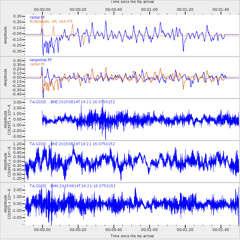
G03D McMinnville, OR, USA - Earthquake Result Viewer
*The percent match for this event was below the threshold and hence no stack was calculated.
| Earthquake location: |
South Of Fiji Islands |
| Earthquake latitude/longitude: |
-26.1/-177.1 |
| Earthquake time(UTC): |
2015/08/14 (226) 14:09:16 GMT |
| Earthquake Depth: |
96 km |
| Earthquake Magnitude: |
5.4 MW |
| Earthquake Catalog/Contributor: |
ISC/ISC |
|
| Network: |
TA USArray Transportable Network (new EarthScope stations) |
| Station: |
G03D McMinnville, OR, USA |
| Lat/Lon: |
45.21 N/123.26 W |
| Elevation: |
222 m |
|
| Distance: |
86.3 deg |
| Az: |
34.875 deg |
| Baz: |
226.651 deg |
| Ray Param: |
$rayparam |
*The percent match for this event was below the threshold and hence was not used in the summary stack. |
|
| Radial Match: |
77.376595 % |
| Radial Bump: |
400 |
| Transverse Match: |
65.10939 % |
| Transverse Bump: |
400 |
| SOD ConfigId: |
7422571 |
| Insert Time: |
2019-04-20 10:06:03.044 +0000 |
| GWidth: |
2.5 |
| Max Bumps: |
400 |
| Tol: |
0.001 |
|
Signal To Noise
| Channel | StoN | STA | LTA |
| TA:G03D: :BHZ:20150814T14:21:16.075015Z | 1.3889278 | 5.121521E-7 | 3.687392E-7 |
| TA:G03D: :BHN:20150814T14:21:16.075015Z | 2.1487274 | 1.0479605E-6 | 4.8771216E-7 |
| TA:G03D: :BHE:20150814T14:21:16.075015Z | 2.0198758 | 1.0049629E-6 | 4.9753703E-7 |
| Arrivals |
| Ps | |
| PpPs | |
| PsPs/PpSs | |


