You are here: Home > Network List > GS - US Geological Survey Networks Stations List
> Station DEC07 Decatur Surface Seismic Site, Decatur, IL, USA > Earthquake Result Viewer
DEC07 Decatur Surface Seismic Site, Decatur, IL, USA - Earthquake Result Viewer
*The percent match for this event was below the threshold and hence no stack was calculated.
| Earthquake location: |
Central Peru |
| Earthquake latitude/longitude: |
-14.6/-71.1 |
| Earthquake time(UTC): |
2015/04/21 (111) 19:00:17 GMT |
| Earthquake Depth: |
119 km |
| Earthquake Magnitude: |
5.6 MB |
| Earthquake Catalog/Contributor: |
NEIC PDE/NEIC COMCAT |
|
| Network: |
GS US Geological Survey Networks |
| Station: |
DEC07 Decatur Surface Seismic Site, Decatur, IL, USA |
| Lat/Lon: |
39.86 N/88.90 W |
| Elevation: |
212 m |
|
| Distance: |
56.7 deg |
| Az: |
343.651 deg |
| Baz: |
159.263 deg |
| Ray Param: |
$rayparam |
*The percent match for this event was below the threshold and hence was not used in the summary stack. |
|
| Radial Match: |
53.150978 % |
| Radial Bump: |
357 |
| Transverse Match: |
67.559494 % |
| Transverse Bump: |
400 |
| SOD ConfigId: |
872571 |
| Insert Time: |
2015-05-05 19:06:26.310 +0000 |
| GWidth: |
2.5 |
| Max Bumps: |
400 |
| Tol: |
0.001 |
|
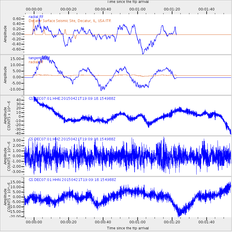
Signal To Noise
| Channel | StoN | STA | LTA |
| GS:DEC07:01:HHZ:20150421T19:09:18.154988Z | 1.3309802 | 1.36976E-6 | 1.0291363E-6 |
| GS:DEC07:01:HHN:20150421T19:09:18.154988Z | 0.99276894 | 6.8144805E-6 | 6.864115E-6 |
| GS:DEC07:01:HHE:20150421T19:09:18.154988Z | 0.952865 | 1.6566391E-5 | 1.7385875E-5 |
| Arrivals |
| Ps | |
| PpPs | |
| PsPs/PpSs | |


