You are here: Home > Network List > CI - Caltech Regional Seismic Network Stations List
> Station GLA Glamis, Glamis, CA, USA > Earthquake Result Viewer
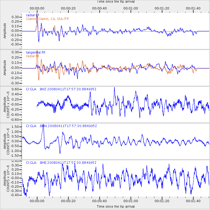
GLA Glamis, Glamis, CA, USA - Earthquake Result Viewer
*The percent match for this event was below the threshold and hence no stack was calculated.
| Earthquake location: |
Loyalty Islands |
| Earthquake latitude/longitude: |
-20.4/168.8 |
| Earthquake time(UTC): |
2008/04/11 (102) 17:45:05 GMT |
| Earthquake Depth: |
35 km |
| Earthquake Magnitude: |
5.7 MB, 5.9 MS, 6.0 MW, 6.0 MW |
| Earthquake Catalog/Contributor: |
WHDF/NEIC |
|
| Network: |
CI Caltech Regional Seismic Network |
| Station: |
GLA Glamis, Glamis, CA, USA |
| Lat/Lon: |
33.05 N/114.83 W |
| Elevation: |
610 m |
|
| Distance: |
90.1 deg |
| Az: |
54.701 deg |
| Baz: |
245.72 deg |
| Ray Param: |
$rayparam |
*The percent match for this event was below the threshold and hence was not used in the summary stack. |
|
| Radial Match: |
75.091896 % |
| Radial Bump: |
400 |
| Transverse Match: |
66.38718 % |
| Transverse Bump: |
400 |
| SOD ConfigId: |
2504 |
| Insert Time: |
2010-02-25 23:36:36.773 +0000 |
| GWidth: |
2.5 |
| Max Bumps: |
400 |
| Tol: |
0.001 |
|
Signal To Noise
| Channel | StoN | STA | LTA |
| CI:GLA: :BHN:20080411T17:57:30.884995Z | 3.5946455 | 6.7561695E-7 | 1.8795093E-7 |
| CI:GLA: :BHE:20080411T17:57:30.884995Z | 0.58160365 | 8.840641E-8 | 1.5200457E-7 |
| CI:GLA: :BHZ:20080411T17:57:30.884995Z | 1.3019428 | 1.6423547E-7 | 1.2614646E-7 |
| Arrivals |
| Ps | |
| PpPs | |
| PsPs/PpSs | |


