You are here: Home > Network List > CN - Canadian National Seismograph Network Stations List
> Station INK INUVIK, NT > Earthquake Result Viewer
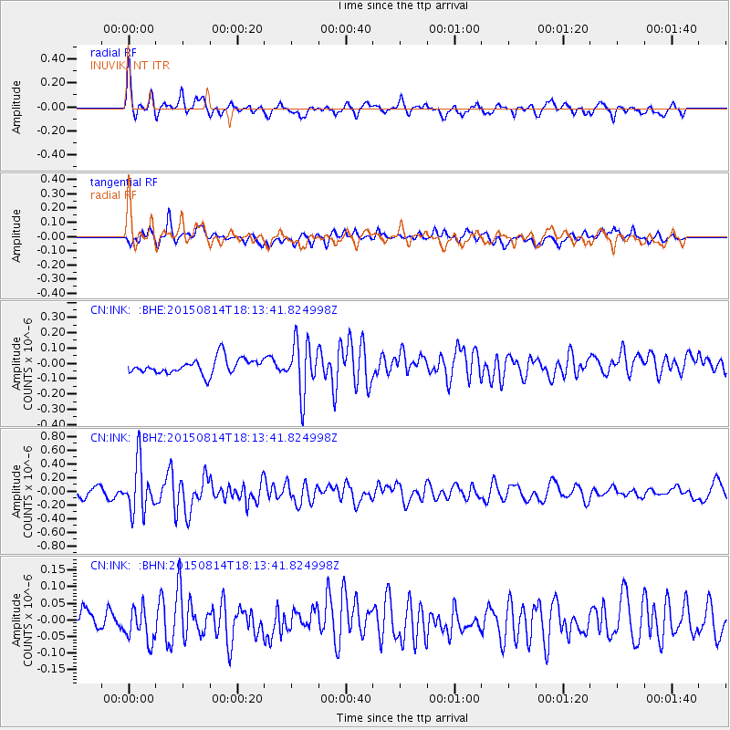
INK INUVIK, NT - Earthquake Result Viewer
*The percent match for this event was below the threshold and hence no stack was calculated.
| Earthquake location: |
Northern Mid-Atlantic Ridge |
| Earthquake latitude/longitude: |
21.1/-45.9 |
| Earthquake time(UTC): |
2015/08/14 (226) 18:03:03 GMT |
| Earthquake Depth: |
13 km |
| Earthquake Magnitude: |
5.5 MB |
| Earthquake Catalog/Contributor: |
NEIC PDE/NEIC COMCAT |
|
| Network: |
CN Canadian National Seismograph Network |
| Station: |
INK INUVIK, NT |
| Lat/Lon: |
68.31 N/133.53 W |
| Elevation: |
44 m |
|
| Distance: |
69.7 deg |
| Az: |
336.669 deg |
| Baz: |
84.03 deg |
| Ray Param: |
$rayparam |
*The percent match for this event was below the threshold and hence was not used in the summary stack. |
|
| Radial Match: |
74.15744 % |
| Radial Bump: |
400 |
| Transverse Match: |
66.87598 % |
| Transverse Bump: |
400 |
| SOD ConfigId: |
7422571 |
| Insert Time: |
2019-04-20 10:11:49.832 +0000 |
| GWidth: |
2.5 |
| Max Bumps: |
400 |
| Tol: |
0.001 |
|
Signal To Noise
| Channel | StoN | STA | LTA |
| CN:INK: :BHZ:20150814T18:13:41.824998Z | 6.183445 | 3.648959E-7 | 5.9011747E-8 |
| CN:INK: :BHN:20150814T18:13:41.824998Z | 1.5022162 | 4.8921294E-8 | 3.256608E-8 |
| CN:INK: :BHE:20150814T18:13:41.824998Z | 3.3329678 | 1.6865799E-7 | 5.060295E-8 |
| Arrivals |
| Ps | |
| PpPs | |
| PsPs/PpSs | |


