You are here: Home > Network List > IU - Global Seismograph Network (GSN - IRIS/USGS) Stations List
> Station CCM Cathedral Cave, Missouri, USA > Earthquake Result Viewer
CCM Cathedral Cave, Missouri, USA - Earthquake Result Viewer

| Earthquake location: |
Near Coast Of Central Chile |
| Earthquake latitude/longitude: |
-29.7/-71.4 |
| Earthquake time(UTC): |
2002/04/01 (091) 19:59:32 GMT |
| Earthquake Depth: |
71 km |
| Earthquake Magnitude: |
6.1 MB, 6.4 MW, 6.4 MW |
| Earthquake Catalog/Contributor: |
WHDF/NEIC |
|
| Network: |
IU Global Seismograph Network (GSN - IRIS/USGS) |
| Station: |
CCM Cathedral Cave, Missouri, USA |
| Lat/Lon: |
38.06 N/91.24 W |
| Elevation: |
222 m |
|
| Distance: |
69.9 deg |
| Az: |
343.405 deg |
| Baz: |
161.647 deg |
| Ray Param: |
0.05518431 |
| Estimated Moho Depth: |
44.75 km |
| Estimated Crust Vp/Vs: |
1.79 |
| Assumed Crust Vp: |
6.498 km/s |
| Estimated Crust Vs: |
3.63 km/s |
| Estimated Crust Poisson's Ratio: |
0.27 |
|
| Radial Match: |
96.27945 % |
| Radial Bump: |
400 |
| Transverse Match: |
78.483086 % |
| Transverse Bump: |
400 |
| SOD ConfigId: |
87546 |
| Insert Time: |
2010-03-04 15:38:01.177 +0000 |
| GWidth: |
2.5 |
| Max Bumps: |
400 |
| Tol: |
0.001 |
|
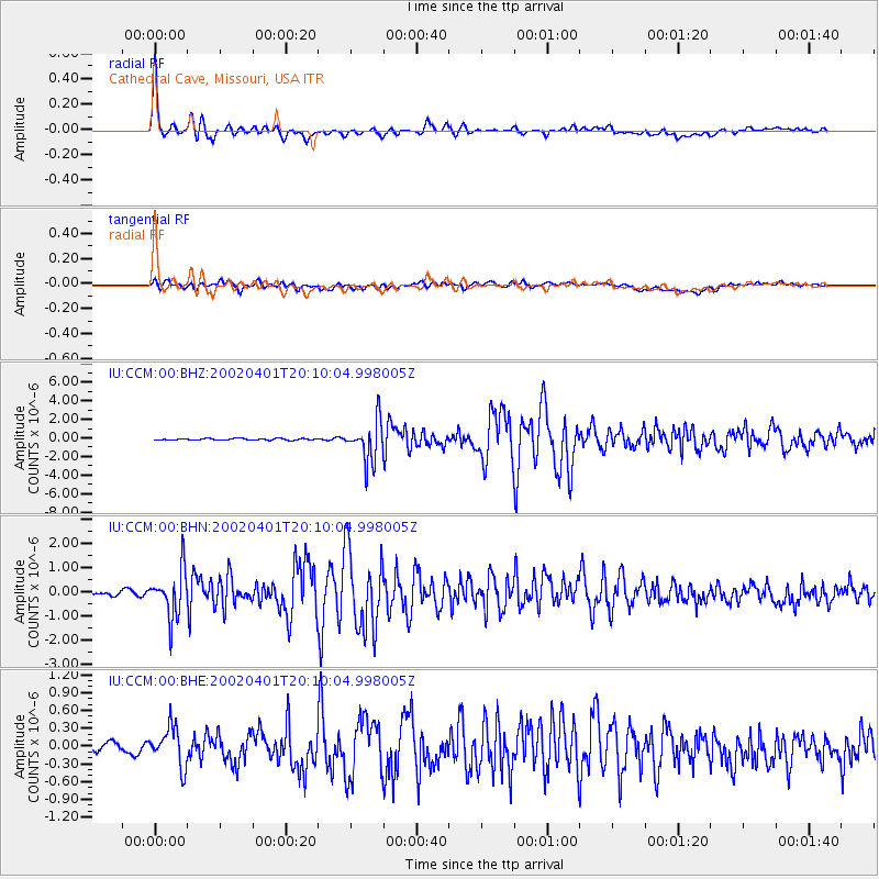
Signal To Noise
| Channel | StoN | STA | LTA |
| IU:CCM:00:BHN:20020401T20:10:04.998005Z | 8.972132 | 9.69441E-7 | 1.0805024E-7 |
| IU:CCM:00:BHE:20020401T20:10:04.998005Z | 3.654271 | 3.2976806E-7 | 9.024183E-8 |
| IU:CCM:00:BHZ:20020401T20:10:04.998005Z | 24.014282 | 2.1657424E-6 | 9.0185594E-8 |
| Arrivals |
| Ps | 5.6 SECOND |
| PpPs | 19 SECOND |
| PsPs/PpSs | 24 SECOND |


