You are here: Home > Network List > N4 - Central and EAstern US Network Stations List
> Station T60A Surry, VA, USA > Earthquake Result Viewer
T60A Surry, VA, USA - Earthquake Result Viewer
| Earthquake location: |
Northern Mid-Atlantic Ridge |
| Earthquake latitude/longitude: |
21.1/-45.9 |
| Earthquake time(UTC): |
2015/08/14 (226) 18:03:03 GMT |
| Earthquake Depth: |
13 km |
| Earthquake Magnitude: |
5.5 MB |
| Earthquake Catalog/Contributor: |
NEIC PDE/NEIC COMCAT |
|
| Network: |
N4 Central and EAstern US Network |
| Station: |
T60A Surry, VA, USA |
| Lat/Lon: |
37.14 N/76.73 W |
| Elevation: |
11 m |
|
| Distance: |
31.2 deg |
| Az: |
307.601 deg |
| Baz: |
112.227 deg |
| Ray Param: |
0.079140976 |
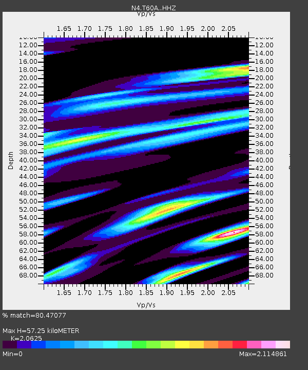
| Estimated Moho Depth: |
57.25 km |
| Estimated Crust Vp/Vs: |
2.06 |
| Assumed Crust Vp: |
6.565 km/s |
| Estimated Crust Vs: |
3.183 km/s |
| Estimated Crust Poisson's Ratio: |
0.35 |
|
| Radial Match: |
80.47077 % |
| Radial Bump: |
241 |
| Transverse Match: |
61.07944 % |
| Transverse Bump: |
343 |
| SOD ConfigId: |
7422571 |
| Insert Time: |
2019-04-20 10:14:54.435 +0000 |
| GWidth: |
2.5 |
| Max Bumps: |
400 |
| Tol: |
0.001 |
|

Signal To Noise
| Channel | StoN | STA | LTA |
| N4:T60A: :HHZ:20150814T18:08:51.580002Z | 2.6286533 | 2.7436056E-7 | 1.0437306E-7 |
| N4:T60A: :HHN:20150814T18:08:51.580002Z | 1.4182187 | 4.1697564E-7 | 2.9401363E-7 |
| N4:T60A: :HHE:20150814T18:08:51.580002Z | 0.9746244 | 3.0421705E-7 | 3.1213773E-7 |
| Arrivals |
| Ps | 10.0 SECOND |
| PpPs | 25 SECOND |
| PsPs/PpSs | 35 SECOND |


