You are here: Home > Network List > IU - Global Seismograph Network (GSN - IRIS/USGS) Stations List
> Station CCM Cathedral Cave, Missouri, USA > Earthquake Result Viewer
CCM Cathedral Cave, Missouri, USA - Earthquake Result Viewer
| Earthquake location: |
Eastern Honshu, Japan |
| Earthquake latitude/longitude: |
38.4/141.0 |
| Earthquake time(UTC): |
2003/07/25 (206) 22:13:29 GMT |
| Earthquake Depth: |
6.0 km |
| Earthquake Magnitude: |
6.0 MB, 5.8 MS, 6.1 MW, 5.9 MW |
| Earthquake Catalog/Contributor: |
WHDF/NEIC |
|
| Network: |
IU Global Seismograph Network (GSN - IRIS/USGS) |
| Station: |
CCM Cathedral Cave, Missouri, USA |
| Lat/Lon: |
38.06 N/91.24 W |
| Elevation: |
222 m |
|
| Distance: |
90.0 deg |
| Az: |
38.616 deg |
| Baz: |
321.607 deg |
| Ray Param: |
0.04170572 |
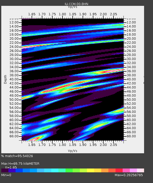
| Estimated Moho Depth: |
69.75 km |
| Estimated Crust Vp/Vs: |
1.65 |
| Assumed Crust Vp: |
6.498 km/s |
| Estimated Crust Vs: |
3.938 km/s |
| Estimated Crust Poisson's Ratio: |
0.21 |
|
| Radial Match: |
95.54826 % |
| Radial Bump: |
376 |
| Transverse Match: |
86.4665 % |
| Transverse Bump: |
400 |
| SOD ConfigId: |
87546 |
| Insert Time: |
2010-03-04 15:38:36.006 +0000 |
| GWidth: |
2.5 |
| Max Bumps: |
400 |
| Tol: |
0.001 |
|

Signal To Noise
| Channel | StoN | STA | LTA |
| IU:CCM:00:BHN:20030725T22:25:58.647002Z | 3.0928833 | 9.763168E-8 | 3.1566557E-8 |
| IU:CCM:00:BHE:20030725T22:25:58.647002Z | 2.4016006 | 9.813611E-8 | 4.0862798E-8 |
| IU:CCM:00:BHZ:20030725T22:25:58.647002Z | 4.6824727 | 3.0697504E-7 | 6.555832E-8 |
| Arrivals |
| Ps | 7.1 SECOND |
| PpPs | 28 SECOND |
| PsPs/PpSs | 35 SECOND |


