You are here: Home > Network List > TA - USArray Transportable Network (new EarthScope stations) Stations List
> Station C06D Leavenworth, WQ, USA > Earthquake Result Viewer
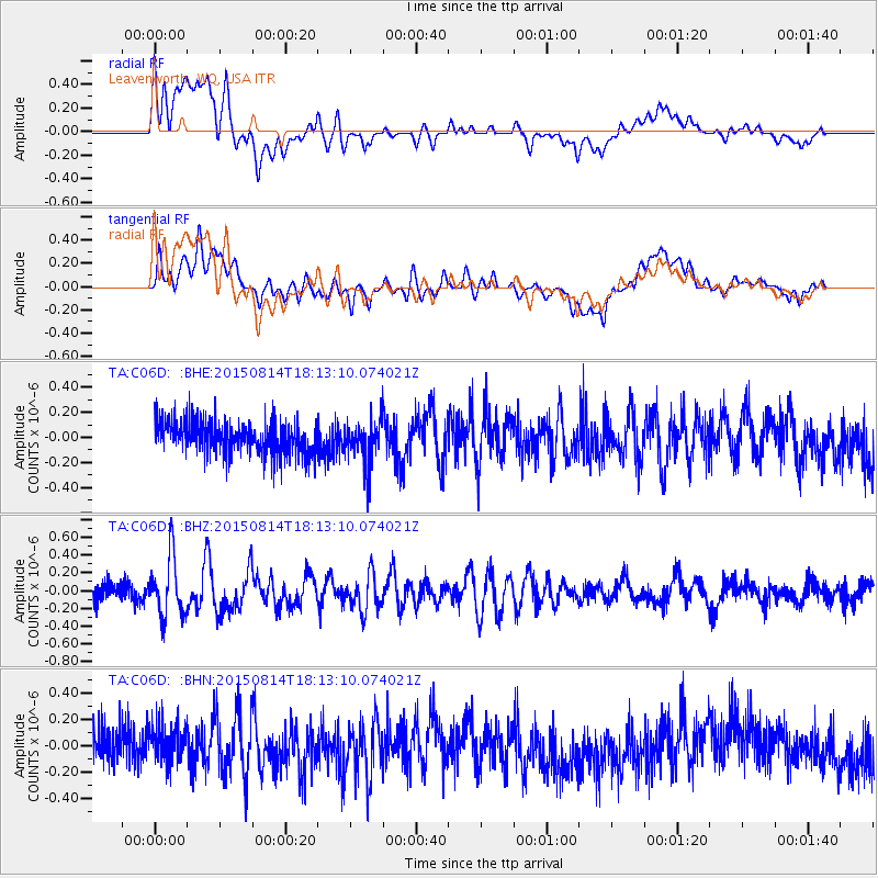
C06D Leavenworth, WQ, USA - Earthquake Result Viewer
*The percent match for this event was below the threshold and hence no stack was calculated.
| Earthquake location: |
Northern Mid-Atlantic Ridge |
| Earthquake latitude/longitude: |
21.1/-45.9 |
| Earthquake time(UTC): |
2015/08/14 (226) 18:03:03 GMT |
| Earthquake Depth: |
13 km |
| Earthquake Magnitude: |
5.5 MB |
| Earthquake Catalog/Contributor: |
NEIC PDE/NEIC COMCAT |
|
| Network: |
TA USArray Transportable Network (new EarthScope stations) |
| Station: |
C06D Leavenworth, WQ, USA |
| Lat/Lon: |
47.92 N/120.89 W |
| Elevation: |
544 m |
|
| Distance: |
64.7 deg |
| Az: |
314.055 deg |
| Baz: |
86.053 deg |
| Ray Param: |
$rayparam |
*The percent match for this event was below the threshold and hence was not used in the summary stack. |
|
| Radial Match: |
63.565636 % |
| Radial Bump: |
400 |
| Transverse Match: |
52.929897 % |
| Transverse Bump: |
400 |
| SOD ConfigId: |
7422571 |
| Insert Time: |
2019-04-20 10:17:18.064 +0000 |
| GWidth: |
2.5 |
| Max Bumps: |
400 |
| Tol: |
0.001 |
|
Signal To Noise
| Channel | StoN | STA | LTA |
| TA:C06D: :BHZ:20150814T18:13:10.074021Z | 3.0137503 | 3.336965E-7 | 1.1072467E-7 |
| TA:C06D: :BHN:20150814T18:13:10.074021Z | 0.93246686 | 1.509568E-7 | 1.6188972E-7 |
| TA:C06D: :BHE:20150814T18:13:10.074021Z | 1.3587812 | 1.8269482E-7 | 1.3445491E-7 |
| Arrivals |
| Ps | |
| PpPs | |
| PsPs/PpSs | |


