You are here: Home > Network List > TA - USArray Transportable Network (new EarthScope stations) Stations List
> Station J62A Henniker, NH, USA > Earthquake Result Viewer
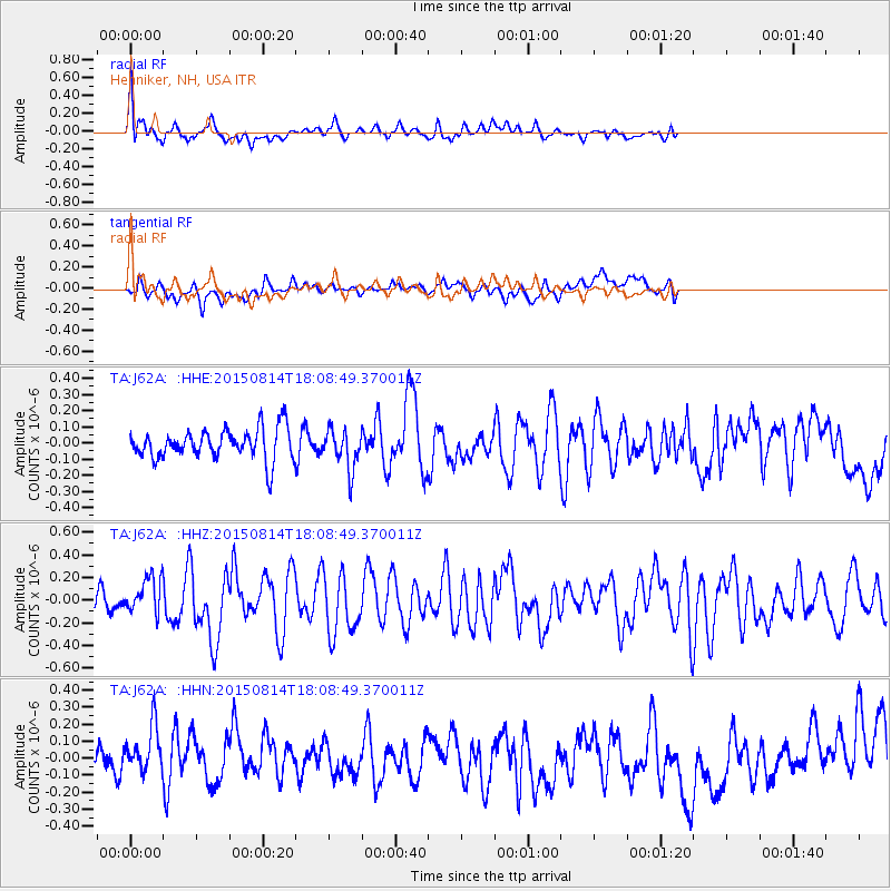
J62A Henniker, NH, USA - Earthquake Result Viewer
*The percent match for this event was below the threshold and hence no stack was calculated.
| Earthquake location: |
Northern Mid-Atlantic Ridge |
| Earthquake latitude/longitude: |
21.1/-45.9 |
| Earthquake time(UTC): |
2015/08/14 (226) 18:03:03 GMT |
| Earthquake Depth: |
13 km |
| Earthquake Magnitude: |
5.5 MB |
| Earthquake Catalog/Contributor: |
NEIC PDE/NEIC COMCAT |
|
| Network: |
TA USArray Transportable Network (new EarthScope stations) |
| Station: |
J62A Henniker, NH, USA |
| Lat/Lon: |
43.23 N/71.81 W |
| Elevation: |
266 m |
|
| Distance: |
30.9 deg |
| Az: |
321.492 deg |
| Baz: |
127.316 deg |
| Ray Param: |
$rayparam |
*The percent match for this event was below the threshold and hence was not used in the summary stack. |
|
| Radial Match: |
61.685406 % |
| Radial Bump: |
400 |
| Transverse Match: |
56.802883 % |
| Transverse Bump: |
400 |
| SOD ConfigId: |
7422571 |
| Insert Time: |
2019-04-20 10:17:46.904 +0000 |
| GWidth: |
2.5 |
| Max Bumps: |
400 |
| Tol: |
0.001 |
|
Signal To Noise
| Channel | StoN | STA | LTA |
| TA:J62A: :HHZ:20150814T18:08:49.370011Z | 1.4426113 | 1.5752563E-7 | 1.0919479E-7 |
| TA:J62A: :HHN:20150814T18:08:49.370011Z | 1.6222708 | 1.5215163E-7 | 9.378929E-8 |
| TA:J62A: :HHE:20150814T18:08:49.370011Z | 1.2970736 | 1.2298307E-7 | 9.48158E-8 |
| Arrivals |
| Ps | |
| PpPs | |
| PsPs/PpSs | |


