You are here: Home > Network List > TA - USArray Transportable Network (new EarthScope stations) Stations List
> Station O18K Koktuh Hills, AK, USA > Earthquake Result Viewer
O18K Koktuh Hills, AK, USA - Earthquake Result Viewer

| Earthquake location: |
Northern Mid-Atlantic Ridge |
| Earthquake latitude/longitude: |
21.1/-45.9 |
| Earthquake time(UTC): |
2015/08/14 (226) 18:03:03 GMT |
| Earthquake Depth: |
13 km |
| Earthquake Magnitude: |
5.5 MB |
| Earthquake Catalog/Contributor: |
NEIC PDE/NEIC COMCAT |
|
| Network: |
TA USArray Transportable Network (new EarthScope stations) |
| Station: |
O18K Koktuh Hills, AK, USA |
| Lat/Lon: |
59.85 N/155.21 W |
| Elevation: |
544 m |
|
| Distance: |
81.2 deg |
| Az: |
331.186 deg |
| Baz: |
63.071 deg |
| Ray Param: |
0.047756072 |
| Estimated Moho Depth: |
55.0 km |
| Estimated Crust Vp/Vs: |
1.95 |
| Assumed Crust Vp: |
6.438 km/s |
| Estimated Crust Vs: |
3.302 km/s |
| Estimated Crust Poisson's Ratio: |
0.32 |
|
| Radial Match: |
84.59625 % |
| Radial Bump: |
400 |
| Transverse Match: |
74.04219 % |
| Transverse Bump: |
400 |
| SOD ConfigId: |
7422571 |
| Insert Time: |
2019-04-20 10:18:18.082 +0000 |
| GWidth: |
2.5 |
| Max Bumps: |
400 |
| Tol: |
0.001 |
|
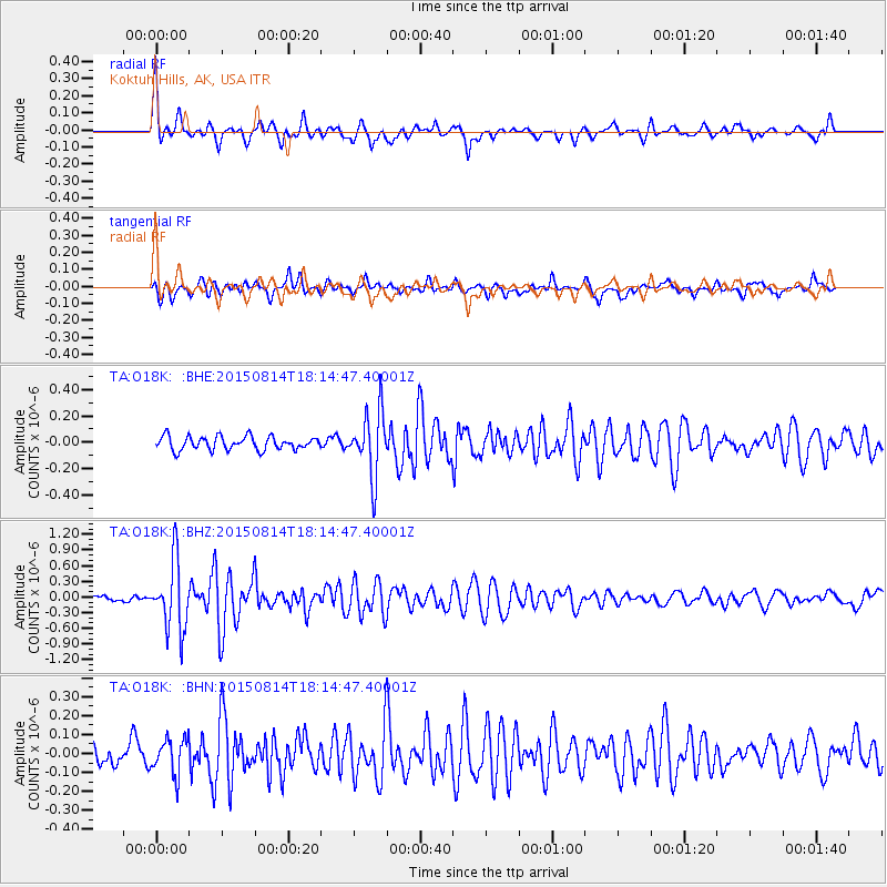
Signal To Noise
| Channel | StoN | STA | LTA |
| TA:O18K: :BHZ:20150814T18:14:47.40001Z | 12.27533 | 6.562663E-7 | 5.3462216E-8 |
| TA:O18K: :BHN:20150814T18:14:47.40001Z | 1.3671674 | 9.211196E-8 | 6.737431E-8 |
| TA:O18K: :BHE:20150814T18:14:47.40001Z | 4.7556276 | 2.4247586E-7 | 5.0987147E-8 |
| Arrivals |
| Ps | 8.3 SECOND |
| PpPs | 25 SECOND |
| PsPs/PpSs | 33 SECOND |


