You are here: Home > Network List > TA - USArray Transportable Network (new EarthScope stations) Stations List
> Station TCOL CIGO, UAF Yankovich Road, Fairbanks, AK, USA > Earthquake Result Viewer
TCOL CIGO, UAF Yankovich Road, Fairbanks, AK, USA - Earthquake Result Viewer
| Earthquake location: |
Northern Mid-Atlantic Ridge |
| Earthquake latitude/longitude: |
21.1/-45.9 |
| Earthquake time(UTC): |
2015/08/14 (226) 18:03:03 GMT |
| Earthquake Depth: |
13 km |
| Earthquake Magnitude: |
5.5 MB |
| Earthquake Catalog/Contributor: |
NEIC PDE/NEIC COMCAT |
|
| Network: |
TA USArray Transportable Network (new EarthScope stations) |
| Station: |
TCOL CIGO, UAF Yankovich Road, Fairbanks, AK, USA |
| Lat/Lon: |
64.87 N/147.86 W |
| Elevation: |
178 m |
|
| Distance: |
76.1 deg |
| Az: |
334.51 deg |
| Baz: |
70.234 deg |
| Ray Param: |
0.051249593 |
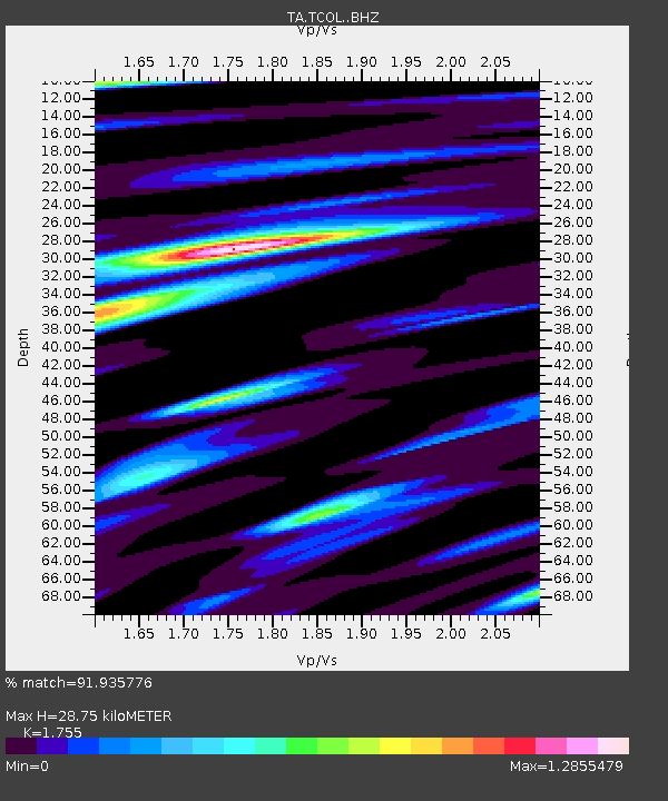
| Estimated Moho Depth: |
28.75 km |
| Estimated Crust Vp/Vs: |
1.75 |
| Assumed Crust Vp: |
6.566 km/s |
| Estimated Crust Vs: |
3.741 km/s |
| Estimated Crust Poisson's Ratio: |
0.26 |
|
| Radial Match: |
91.935776 % |
| Radial Bump: |
392 |
| Transverse Match: |
83.7738 % |
| Transverse Bump: |
400 |
| SOD ConfigId: |
7422571 |
| Insert Time: |
2019-04-20 10:18:29.959 +0000 |
| GWidth: |
2.5 |
| Max Bumps: |
400 |
| Tol: |
0.001 |
|

Signal To Noise
| Channel | StoN | STA | LTA |
| TA:TCOL: :BHZ:20150814T18:14:19.225022Z | 2.7281303 | 7.926628E-7 | 2.9055164E-7 |
| TA:TCOL: :BHN:20150814T18:14:19.225022Z | 1.5466646 | 4.1382165E-7 | 2.6755748E-7 |
| TA:TCOL: :BHE:20150814T18:14:19.225022Z | 1.955195 | 4.77071E-7 | 2.4400177E-7 |
| Arrivals |
| Ps | 3.4 SECOND |
| PpPs | 12 SECOND |
| PsPs/PpSs | 15 SECOND |


