You are here: Home > Network List > TA - USArray Transportable Network (new EarthScope stations) Stations List
> Station TPFO Pinon Flats, CA, USA > Earthquake Result Viewer
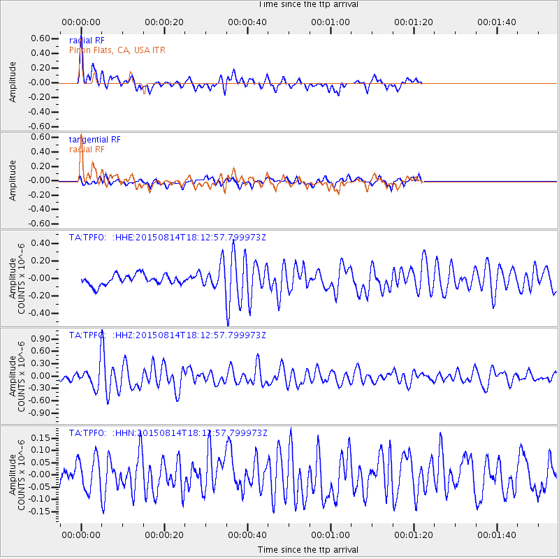
TPFO Pinon Flats, CA, USA - Earthquake Result Viewer
*The percent match for this event was below the threshold and hence no stack was calculated.
| Earthquake location: |
Northern Mid-Atlantic Ridge |
| Earthquake latitude/longitude: |
21.1/-45.9 |
| Earthquake time(UTC): |
2015/08/14 (226) 18:03:03 GMT |
| Earthquake Depth: |
13 km |
| Earthquake Magnitude: |
5.5 MB |
| Earthquake Catalog/Contributor: |
NEIC PDE/NEIC COMCAT |
|
| Network: |
TA USArray Transportable Network (new EarthScope stations) |
| Station: |
TPFO Pinon Flats, CA, USA |
| Lat/Lon: |
33.61 N/116.45 W |
| Elevation: |
1275 m |
|
| Distance: |
62.8 deg |
| Az: |
297.8 deg |
| Baz: |
81.741 deg |
| Ray Param: |
$rayparam |
*The percent match for this event was below the threshold and hence was not used in the summary stack. |
|
| Radial Match: |
75.3651 % |
| Radial Bump: |
400 |
| Transverse Match: |
56.75723 % |
| Transverse Bump: |
400 |
| SOD ConfigId: |
7422571 |
| Insert Time: |
2019-04-20 10:18:30.505 +0000 |
| GWidth: |
2.5 |
| Max Bumps: |
400 |
| Tol: |
0.001 |
|
Signal To Noise
| Channel | StoN | STA | LTA |
| TA:TPFO: :HHZ:20150814T18:12:57.799973Z | 3.4229968 | 3.0974488E-7 | 9.048939E-8 |
| TA:TPFO: :HHN:20150814T18:12:57.799973Z | 1.12391 | 7.1192694E-8 | 6.3343776E-8 |
| TA:TPFO: :HHE:20150814T18:12:57.799973Z | 2.595051 | 1.5172301E-7 | 5.8466295E-8 |
| Arrivals |
| Ps | |
| PpPs | |
| PsPs/PpSs | |


