You are here: Home > Network List > US - United States National Seismic Network Stations List
> Station DGMT Dagmar, Montana, USA > Earthquake Result Viewer
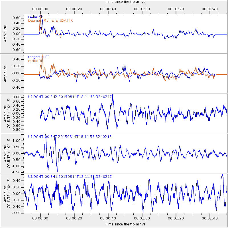
DGMT Dagmar, Montana, USA - Earthquake Result Viewer
*The percent match for this event was below the threshold and hence no stack was calculated.
| Earthquake location: |
Northern Mid-Atlantic Ridge |
| Earthquake latitude/longitude: |
21.1/-45.9 |
| Earthquake time(UTC): |
2015/08/14 (226) 18:03:03 GMT |
| Earthquake Depth: |
13 km |
| Earthquake Magnitude: |
5.5 MB |
| Earthquake Catalog/Contributor: |
NEIC PDE/NEIC COMCAT |
|
| Network: |
US United States National Seismic Network |
| Station: |
DGMT Dagmar, Montana, USA |
| Lat/Lon: |
48.47 N/104.20 W |
| Elevation: |
0.0 m |
|
| Distance: |
53.6 deg |
| Az: |
315.272 deg |
| Baz: |
99.131 deg |
| Ray Param: |
$rayparam |
*The percent match for this event was below the threshold and hence was not used in the summary stack. |
|
| Radial Match: |
61.111576 % |
| Radial Bump: |
400 |
| Transverse Match: |
57.428303 % |
| Transverse Bump: |
400 |
| SOD ConfigId: |
7422571 |
| Insert Time: |
2019-04-20 10:19:03.969 +0000 |
| GWidth: |
2.5 |
| Max Bumps: |
400 |
| Tol: |
0.001 |
|
Signal To Noise
| Channel | StoN | STA | LTA |
| US:DGMT:00:BHZ:20150814T18:11:53.324021Z | 5.309365 | 6.692468E-7 | 1.2605025E-7 |
| US:DGMT:00:BH1:20150814T18:11:53.324021Z | 1.0811429 | 1.658753E-7 | 1.5342589E-7 |
| US:DGMT:00:BH2:20150814T18:11:53.324021Z | 1.5411427 | 3.1316483E-7 | 2.03203E-7 |
| Arrivals |
| Ps | |
| PpPs | |
| PsPs/PpSs | |


