You are here: Home > Network List > IU - Global Seismograph Network (GSN - IRIS/USGS) Stations List
> Station CCM Cathedral Cave, Missouri, USA > Earthquake Result Viewer
CCM Cathedral Cave, Missouri, USA - Earthquake Result Viewer

| Earthquake location: |
Northern Chile |
| Earthquake latitude/longitude: |
-20.0/-69.2 |
| Earthquake time(UTC): |
2005/06/13 (164) 22:44:33 GMT |
| Earthquake Depth: |
116 km |
| Earthquake Magnitude: |
6.8 MB, 7.8 MW, 7.8 MW |
| Earthquake Catalog/Contributor: |
WHDF/NEIC |
|
| Network: |
IU Global Seismograph Network (GSN - IRIS/USGS) |
| Station: |
CCM Cathedral Cave, Missouri, USA |
| Lat/Lon: |
38.06 N/91.24 W |
| Elevation: |
222 m |
|
| Distance: |
61.3 deg |
| Az: |
340.263 deg |
| Baz: |
156.276 deg |
| Ray Param: |
0.060611576 |
| Estimated Moho Depth: |
46.75 km |
| Estimated Crust Vp/Vs: |
1.72 |
| Assumed Crust Vp: |
6.498 km/s |
| Estimated Crust Vs: |
3.789 km/s |
| Estimated Crust Poisson's Ratio: |
0.24 |
|
| Radial Match: |
99.054054 % |
| Radial Bump: |
180 |
| Transverse Match: |
94.431854 % |
| Transverse Bump: |
400 |
| SOD ConfigId: |
87546 |
| Insert Time: |
2010-03-04 15:39:37.617 +0000 |
| GWidth: |
2.5 |
| Max Bumps: |
400 |
| Tol: |
0.001 |
|
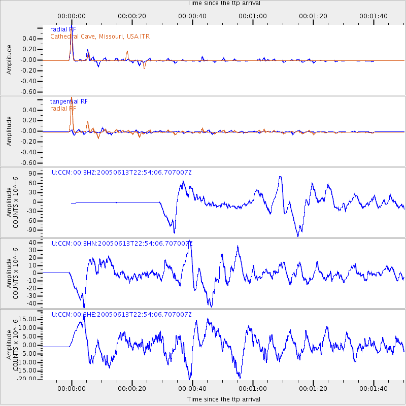
Signal To Noise
| Channel | StoN | STA | LTA |
| IU:CCM:00:BHN:20050613T22:54:06.707007Z | 43.432724 | 2.439542E-5 | 5.6168295E-7 |
| IU:CCM:00:BHE:20050613T22:54:06.707007Z | 37.45 | 1.0190987E-5 | 2.721225E-7 |
| IU:CCM:00:BHZ:20050613T22:54:06.707007Z | 57.826283 | 5.346398E-5 | 9.2456196E-7 |
| Arrivals |
| Ps | 5.4 SECOND |
| PpPs | 19 SECOND |
| PsPs/PpSs | 24 SECOND |


