You are here: Home > Network List > UW - Pacific Northwest Regional Seismic Network Stations List
> Station MRBL Marblemount, WA, USA > Earthquake Result Viewer
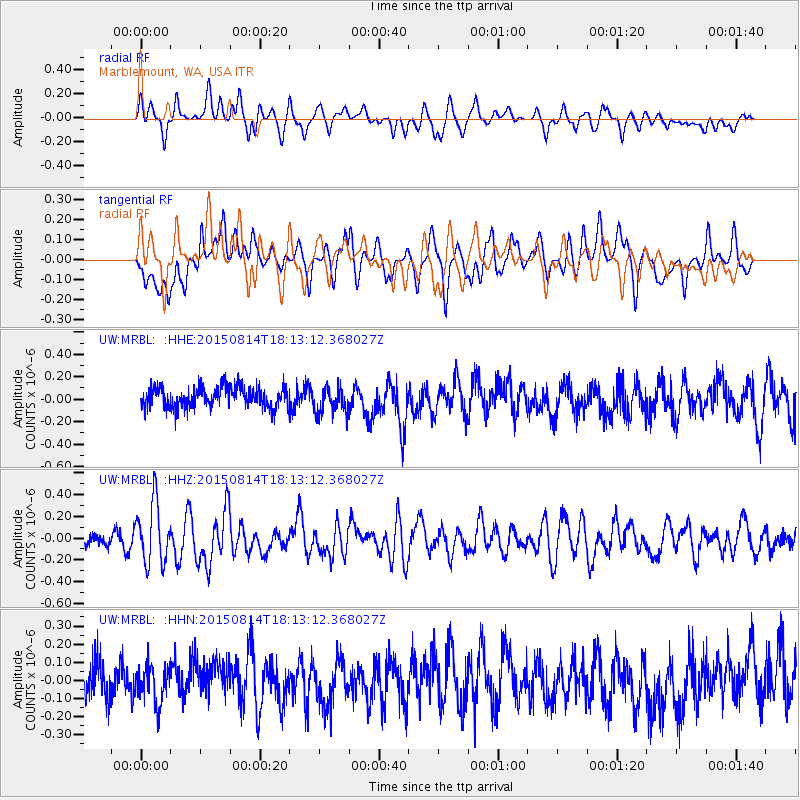
MRBL Marblemount, WA, USA - Earthquake Result Viewer
*The percent match for this event was below the threshold and hence no stack was calculated.
| Earthquake location: |
Northern Mid-Atlantic Ridge |
| Earthquake latitude/longitude: |
21.1/-45.9 |
| Earthquake time(UTC): |
2015/08/14 (226) 18:03:03 GMT |
| Earthquake Depth: |
13 km |
| Earthquake Magnitude: |
5.5 MB |
| Earthquake Catalog/Contributor: |
NEIC PDE/NEIC COMCAT |
|
| Network: |
UW Pacific Northwest Regional Seismic Network |
| Station: |
MRBL Marblemount, WA, USA |
| Lat/Lon: |
48.52 N/121.48 W |
| Elevation: |
75 m |
|
| Distance: |
65.1 deg |
| Az: |
314.742 deg |
| Baz: |
85.906 deg |
| Ray Param: |
$rayparam |
*The percent match for this event was below the threshold and hence was not used in the summary stack. |
|
| Radial Match: |
59.944294 % |
| Radial Bump: |
400 |
| Transverse Match: |
53.48872 % |
| Transverse Bump: |
400 |
| SOD ConfigId: |
7422571 |
| Insert Time: |
2019-04-20 10:19:26.292 +0000 |
| GWidth: |
2.5 |
| Max Bumps: |
400 |
| Tol: |
0.001 |
|
Signal To Noise
| Channel | StoN | STA | LTA |
| UW:MRBL: :HHZ:20150814T18:13:12.368027Z | 4.5338697 | 2.838279E-7 | 6.2601686E-8 |
| UW:MRBL: :HHN:20150814T18:13:12.368027Z | 0.84743613 | 1.05746935E-7 | 1.2478455E-7 |
| UW:MRBL: :HHE:20150814T18:13:12.368027Z | 1.304088 | 1.195677E-7 | 9.1686836E-8 |
| Arrivals |
| Ps | |
| PpPs | |
| PsPs/PpSs | |


