You are here: Home > Network List > IU - Global Seismograph Network (GSN - IRIS/USGS) Stations List
> Station CCM Cathedral Cave, Missouri, USA > Earthquake Result Viewer
CCM Cathedral Cave, Missouri, USA - Earthquake Result Viewer

| Earthquake location: |
Sakhalin, Russia |
| Earthquake latitude/longitude: |
49.0/141.9 |
| Earthquake time(UTC): |
1990/05/12 (132) 04:50:09 GMT |
| Earthquake Depth: |
611 km |
| Earthquake Magnitude: |
6.4 MB |
| Earthquake Catalog/Contributor: |
WHDF/NEIC |
|
| Network: |
IU Global Seismograph Network (GSN - IRIS/USGS) |
| Station: |
CCM Cathedral Cave, Missouri, USA |
| Lat/Lon: |
38.06 N/91.24 W |
| Elevation: |
222 m |
|
| Distance: |
81.3 deg |
| Az: |
39.7 deg |
| Baz: |
327.828 deg |
| Ray Param: |
0.045774013 |
| Estimated Moho Depth: |
66.25 km |
| Estimated Crust Vp/Vs: |
1.61 |
| Assumed Crust Vp: |
6.498 km/s |
| Estimated Crust Vs: |
4.048 km/s |
| Estimated Crust Poisson's Ratio: |
0.18 |
|
| Radial Match: |
96.94129 % |
| Radial Bump: |
400 |
| Transverse Match: |
74.75789 % |
| Transverse Bump: |
400 |
| SOD ConfigId: |
16938 |
| Insert Time: |
2010-03-04 15:40:32.104 +0000 |
| GWidth: |
2.5 |
| Max Bumps: |
400 |
| Tol: |
0.001 |
|
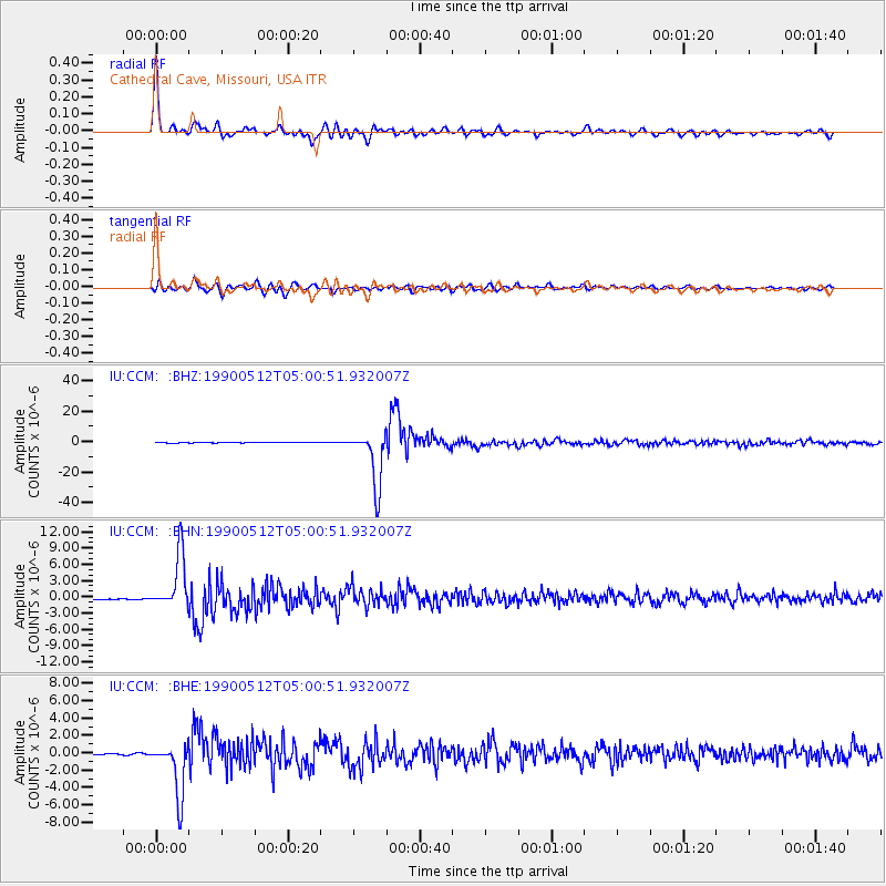
Signal To Noise
| Channel | StoN | STA | LTA |
| IU:CCM: :BHN:19900512T05:00:51.932007Z | 11.92504 | 4.9468163E-6 | 4.1482596E-7 |
| IU:CCM: :BHE:19900512T05:00:51.932007Z | 9.886413 | 3.2273635E-6 | 3.2644434E-7 |
| IU:CCM: :BHZ:19900512T05:00:51.932007Z | 133.67142 | 1.7983353E-5 | 1.3453403E-7 |
| Arrivals |
| Ps | 6.3 SECOND |
| PpPs | 26 SECOND |
| PsPs/PpSs | 32 SECOND |


