You are here: Home > Network List > IU - Global Seismograph Network (GSN - IRIS/USGS) Stations List
> Station CCM Cathedral Cave, Missouri, USA > Earthquake Result Viewer
CCM Cathedral Cave, Missouri, USA - Earthquake Result Viewer
| Earthquake location: |
Near Coast Of Ecuador |
| Earthquake latitude/longitude: |
-0.1/-80.2 |
| Earthquake time(UTC): |
1990/09/02 (245) 04:26:49 GMT |
| Earthquake Depth: |
25 km |
| Earthquake Magnitude: |
5.8 MB, 6.1 MS |
| Earthquake Catalog/Contributor: |
WHDF/NEIC |
|
| Network: |
IU Global Seismograph Network (GSN - IRIS/USGS) |
| Station: |
CCM Cathedral Cave, Missouri, USA |
| Lat/Lon: |
38.06 N/91.24 W |
| Elevation: |
222 m |
|
| Distance: |
39.3 deg |
| Az: |
346.24 deg |
| Baz: |
162.464 deg |
| Ray Param: |
0.07501058 |
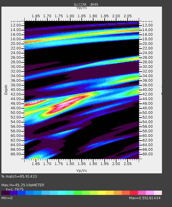
| Estimated Moho Depth: |
45.25 km |
| Estimated Crust Vp/Vs: |
1.79 |
| Assumed Crust Vp: |
6.498 km/s |
| Estimated Crust Vs: |
3.635 km/s |
| Estimated Crust Poisson's Ratio: |
0.27 |
|
| Radial Match: |
95.91433 % |
| Radial Bump: |
249 |
| Transverse Match: |
76.371635 % |
| Transverse Bump: |
400 |
| SOD ConfigId: |
16938 |
| Insert Time: |
2010-03-04 15:40:40.425 +0000 |
| GWidth: |
2.5 |
| Max Bumps: |
400 |
| Tol: |
0.001 |
|

Signal To Noise
| Channel | StoN | STA | LTA |
| IU:CCM: :BHN:19900902T04:33:46.008014Z | 8.144215 | 4.407174E-7 | 5.411417E-8 |
| IU:CCM: :BHE:19900902T04:33:46.008014Z | 2.6971648 | 1.2642806E-7 | 4.6874433E-8 |
| IU:CCM: :BHZ:19900902T04:33:46.008014Z | 8.291505 | 8.4527267E-7 | 1.0194442E-7 |
| Arrivals |
| Ps | 5.9 SECOND |
| PpPs | 18 SECOND |
| PsPs/PpSs | 24 SECOND |


