You are here: Home > Network List > IU - Global Seismograph Network (GSN - IRIS/USGS) Stations List
> Station CCM Cathedral Cave, Missouri, USA > Earthquake Result Viewer
CCM Cathedral Cave, Missouri, USA - Earthquake Result Viewer

| Earthquake location: |
Alaska Peninsula |
| Earthquake latitude/longitude: |
58.8/-156.8 |
| Earthquake time(UTC): |
1990/05/01 (121) 16:12:22 GMT |
| Earthquake Depth: |
217 km |
| Earthquake Magnitude: |
6.1 MB, 6.3 UNKNOWN |
| Earthquake Catalog/Contributor: |
WHDF/NEIC |
|
| Network: |
IU Global Seismograph Network (GSN - IRIS/USGS) |
| Station: |
CCM Cathedral Cave, Missouri, USA |
| Lat/Lon: |
38.06 N/91.24 W |
| Elevation: |
222 m |
|
| Distance: |
46.1 deg |
| Az: |
86.745 deg |
| Baz: |
318.857 deg |
| Ray Param: |
0.07003994 |
| Estimated Moho Depth: |
39.5 km |
| Estimated Crust Vp/Vs: |
1.93 |
| Assumed Crust Vp: |
6.498 km/s |
| Estimated Crust Vs: |
3.362 km/s |
| Estimated Crust Poisson's Ratio: |
0.32 |
|
| Radial Match: |
94.44517 % |
| Radial Bump: |
344 |
| Transverse Match: |
55.80309 % |
| Transverse Bump: |
400 |
| SOD ConfigId: |
17000 |
| Insert Time: |
2010-03-04 15:40:44.608 +0000 |
| GWidth: |
2.5 |
| Max Bumps: |
400 |
| Tol: |
0.001 |
|
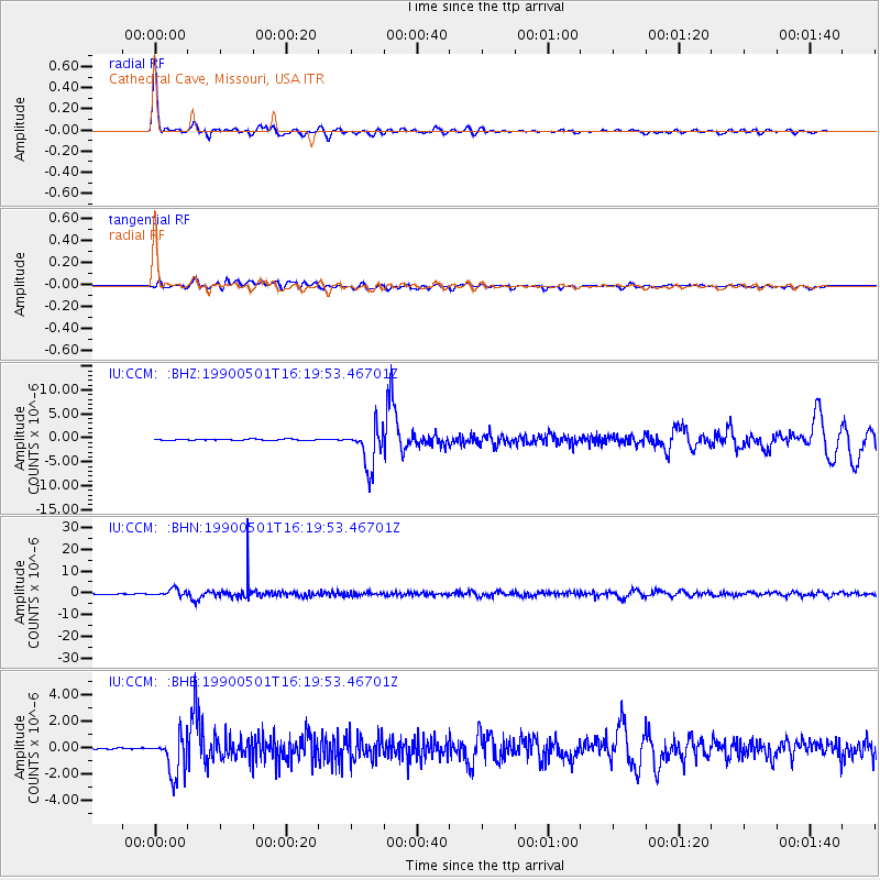
Signal To Noise
| Channel | StoN | STA | LTA |
| IU:CCM: :BHN:19900501T16:19:53.46701Z | 11.355015 | 1.6568264E-6 | 1.4591143E-7 |
| IU:CCM: :BHE:19900501T16:19:53.46701Z | 12.795006 | 1.4691758E-6 | 1.1482416E-7 |
| IU:CCM: :BHZ:19900501T16:19:53.46701Z | 38.398605 | 4.239804E-6 | 1.1041557E-7 |
| Arrivals |
| Ps | 6.0 SECOND |
| PpPs | 17 SECOND |
| PsPs/PpSs | 23 SECOND |


