You are here: Home > Network List > IU - Global Seismograph Network (GSN - IRIS/USGS) Stations List
> Station CCM Cathedral Cave, Missouri, USA > Earthquake Result Viewer
CCM Cathedral Cave, Missouri, USA - Earthquake Result Viewer
| Earthquake location: |
Southern Peru |
| Earthquake latitude/longitude: |
-16.5/-70.7 |
| Earthquake time(UTC): |
1991/05/24 (144) 20:50:55 GMT |
| Earthquake Depth: |
125 km |
| Earthquake Magnitude: |
6.3 MB, 6.8 UNKNOWN |
| Earthquake Catalog/Contributor: |
WHDF/NEIC |
|
| Network: |
IU Global Seismograph Network (GSN - IRIS/USGS) |
| Station: |
CCM Cathedral Cave, Missouri, USA |
| Lat/Lon: |
38.06 N/91.24 W |
| Elevation: |
222 m |
|
| Distance: |
57.6 deg |
| Az: |
340.857 deg |
| Baz: |
156.512 deg |
| Ray Param: |
0.063024275 |
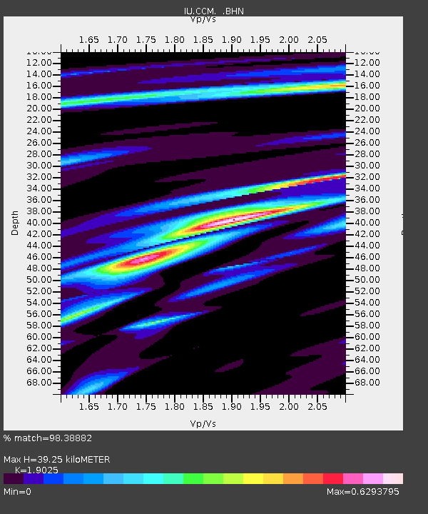
| Estimated Moho Depth: |
39.25 km |
| Estimated Crust Vp/Vs: |
1.90 |
| Assumed Crust Vp: |
6.498 km/s |
| Estimated Crust Vs: |
3.415 km/s |
| Estimated Crust Poisson's Ratio: |
0.31 |
|
| Radial Match: |
98.38882 % |
| Radial Bump: |
359 |
| Transverse Match: |
92.355194 % |
| Transverse Bump: |
400 |
| SOD ConfigId: |
16938 |
| Insert Time: |
2010-03-04 15:40:58.941 +0000 |
| GWidth: |
2.5 |
| Max Bumps: |
400 |
| Tol: |
0.001 |
|

Signal To Noise
| Channel | StoN | STA | LTA |
| IU:CCM: :BHN:19910524T21:00:01.392004Z | 26.102531 | 2.6056487E-6 | 9.9823595E-8 |
| IU:CCM: :BHE:19910524T21:00:01.392004Z | 11.190171 | 9.0503426E-7 | 8.0877605E-8 |
| IU:CCM: :BHZ:19910524T21:00:01.392004Z | 87.988556 | 5.994561E-6 | 6.812887E-8 |
| Arrivals |
| Ps | 5.7 SECOND |
| PpPs | 17 SECOND |
| PsPs/PpSs | 22 SECOND |


