You are here: Home > Network List > IU - Global Seismograph Network (GSN - IRIS/USGS) Stations List
> Station CCM Cathedral Cave, Missouri, USA > Earthquake Result Viewer
CCM Cathedral Cave, Missouri, USA - Earthquake Result Viewer

| Earthquake location: |
Santiago Del Estero Prov., Arg. |
| Earthquake latitude/longitude: |
-26.8/-63.4 |
| Earthquake time(UTC): |
1991/06/23 (174) 21:22:30 GMT |
| Earthquake Depth: |
581 km |
| Earthquake Magnitude: |
6.4 MB, 6.2 UNKNOWN |
| Earthquake Catalog/Contributor: |
WHDF/NEIC |
|
| Network: |
IU Global Seismograph Network (GSN - IRIS/USGS) |
| Station: |
CCM Cathedral Cave, Missouri, USA |
| Lat/Lon: |
38.06 N/91.24 W |
| Elevation: |
222 m |
|
| Distance: |
69.6 deg |
| Az: |
336.839 deg |
| Baz: |
153.561 deg |
| Ray Param: |
0.053505793 |
| Estimated Moho Depth: |
32.5 km |
| Estimated Crust Vp/Vs: |
2.09 |
| Assumed Crust Vp: |
6.498 km/s |
| Estimated Crust Vs: |
3.113 km/s |
| Estimated Crust Poisson's Ratio: |
0.35 |
|
| Radial Match: |
98.25903 % |
| Radial Bump: |
368 |
| Transverse Match: |
94.52739 % |
| Transverse Bump: |
400 |
| SOD ConfigId: |
16938 |
| Insert Time: |
2010-03-04 15:41:08.485 +0000 |
| GWidth: |
2.5 |
| Max Bumps: |
400 |
| Tol: |
0.001 |
|
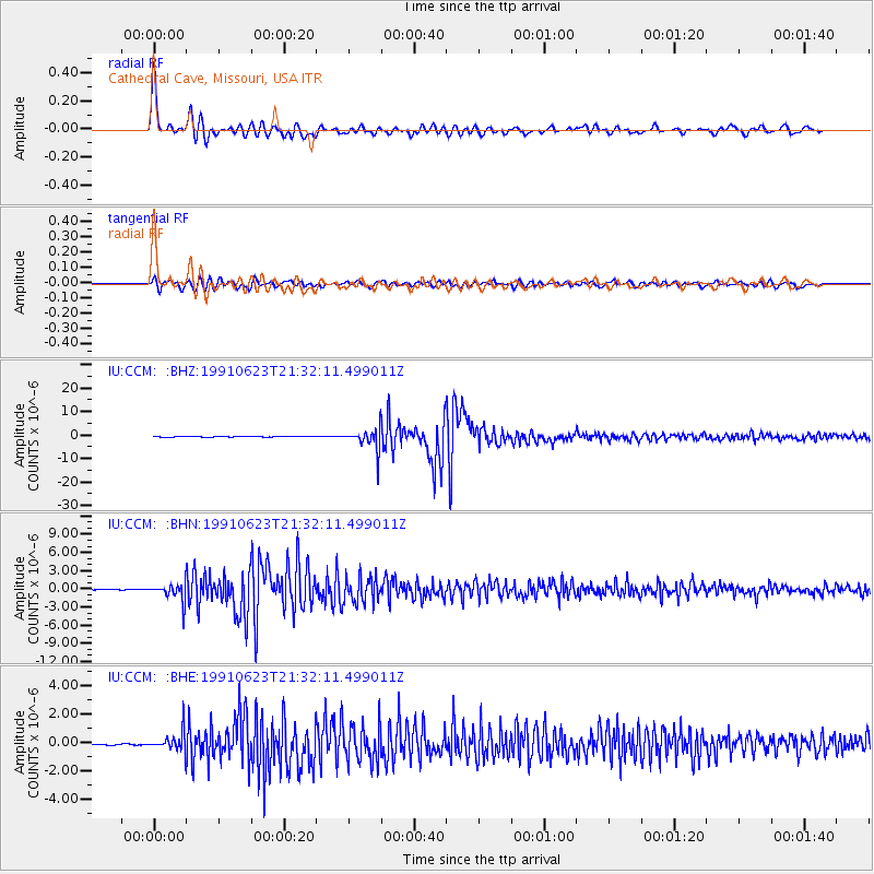
Signal To Noise
| Channel | StoN | STA | LTA |
| IU:CCM: :BHN:19910623T21:32:11.499011Z | 27.601156 | 1.436488E-6 | 5.2044484E-8 |
| IU:CCM: :BHE:19910623T21:32:11.499011Z | 15.450107 | 6.73935E-7 | 4.3620087E-8 |
| IU:CCM: :BHZ:19910623T21:32:11.499011Z | 63.340733 | 4.5455704E-6 | 7.176378E-8 |
| Arrivals |
| Ps | 5.6 SECOND |
| PpPs | 15 SECOND |
| PsPs/PpSs | 21 SECOND |


