You are here: Home > Network List > IU - Global Seismograph Network (GSN - IRIS/USGS) Stations List
> Station CCM Cathedral Cave, Missouri, USA > Earthquake Result Viewer
CCM Cathedral Cave, Missouri, USA - Earthquake Result Viewer

| Earthquake location: |
Northern Colombia |
| Earthquake latitude/longitude: |
6.9/-76.8 |
| Earthquake time(UTC): |
1992/10/17 (291) 08:32:39 GMT |
| Earthquake Depth: |
10 km |
| Earthquake Magnitude: |
6.2 MB, 6.7 MS, 7.0 UNKNOWN |
| Earthquake Catalog/Contributor: |
WHDF/NEIC |
|
| Network: |
IU Global Seismograph Network (GSN - IRIS/USGS) |
| Station: |
CCM Cathedral Cave, Missouri, USA |
| Lat/Lon: |
38.06 N/91.24 W |
| Elevation: |
222 m |
|
| Distance: |
33.7 deg |
| Az: |
339.233 deg |
| Baz: |
153.514 deg |
| Ray Param: |
0.078089446 |
| Estimated Moho Depth: |
54.25 km |
| Estimated Crust Vp/Vs: |
1.69 |
| Assumed Crust Vp: |
6.498 km/s |
| Estimated Crust Vs: |
3.85 km/s |
| Estimated Crust Poisson's Ratio: |
0.23 |
|
| Radial Match: |
94.850235 % |
| Radial Bump: |
239 |
| Transverse Match: |
78.526344 % |
| Transverse Bump: |
400 |
| SOD ConfigId: |
16938 |
| Insert Time: |
2010-03-04 15:41:47.728 +0000 |
| GWidth: |
2.5 |
| Max Bumps: |
400 |
| Tol: |
0.001 |
|
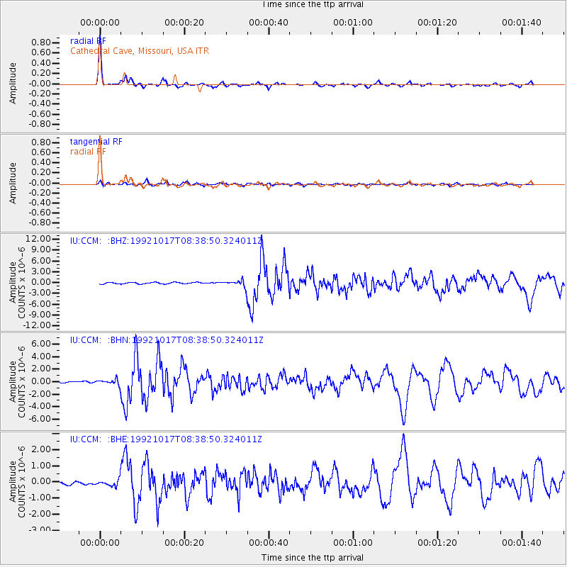
Signal To Noise
| Channel | StoN | STA | LTA |
| IU:CCM: :BHN:19921017T08:38:50.324011Z | 3.5004518 | 4.3940065E-7 | 1.2552684E-7 |
| IU:CCM: :BHE:19921017T08:38:50.324011Z | 2.1765592 | 2.0868768E-7 | 9.587963E-8 |
| IU:CCM: :BHZ:19921017T08:38:50.324011Z | 4.4310594 | 9.511769E-7 | 2.1466127E-7 |
| Arrivals |
| Ps | 6.2 SECOND |
| PpPs | 21 SECOND |
| PsPs/PpSs | 27 SECOND |


