You are here: Home > Network List > IU - Global Seismograph Network (GSN - IRIS/USGS) Stations List
> Station CCM Cathedral Cave, Missouri, USA > Earthquake Result Viewer
CCM Cathedral Cave, Missouri, USA - Earthquake Result Viewer

| Earthquake location: |
Andreanof Islands, Aleutian Is. |
| Earthquake latitude/longitude: |
51.2/-178.2 |
| Earthquake time(UTC): |
1992/09/30 (274) 06:03:25 GMT |
| Earthquake Depth: |
33 km |
| Earthquake Magnitude: |
5.0 MB, 5.5 ML |
| Earthquake Catalog/Contributor: |
WHDF/NEIC |
|
| Network: |
IU Global Seismograph Network (GSN - IRIS/USGS) |
| Station: |
CCM Cathedral Cave, Missouri, USA |
| Lat/Lon: |
38.06 N/91.24 W |
| Elevation: |
222 m |
|
| Distance: |
59.8 deg |
| Az: |
65.828 deg |
| Baz: |
313.342 deg |
| Ray Param: |
0.061909616 |
| Estimated Moho Depth: |
38.75 km |
| Estimated Crust Vp/Vs: |
1.80 |
| Assumed Crust Vp: |
6.498 km/s |
| Estimated Crust Vs: |
3.615 km/s |
| Estimated Crust Poisson's Ratio: |
0.28 |
|
| Radial Match: |
94.94982 % |
| Radial Bump: |
393 |
| Transverse Match: |
81.57153 % |
| Transverse Bump: |
347 |
| SOD ConfigId: |
17000 |
| Insert Time: |
2010-03-04 15:42:02.672 +0000 |
| GWidth: |
2.5 |
| Max Bumps: |
400 |
| Tol: |
0.001 |
|
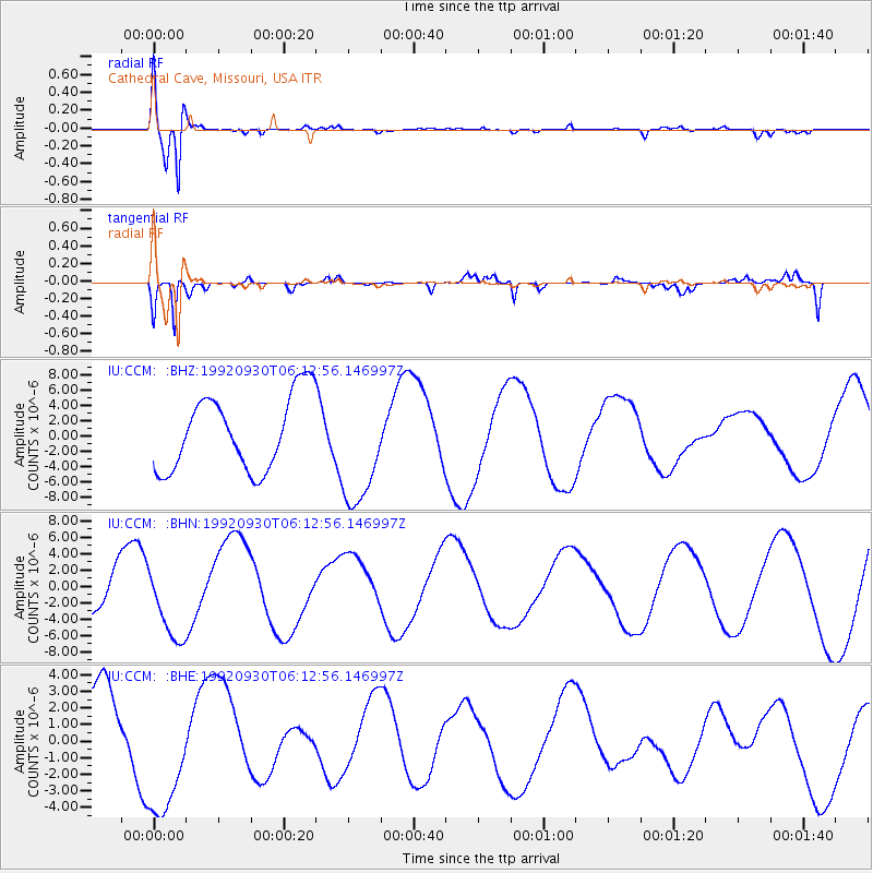
Signal To Noise
| Channel | StoN | STA | LTA |
| IU:CCM: :BHN:19920930T06:12:56.146997Z | 1.9984701 | 4.66837E-6 | 2.3359719E-6 |
| IU:CCM: :BHE:19920930T06:12:56.146997Z | 1.648591 | 4.0034042E-6 | 2.428379E-6 |
| IU:CCM: :BHZ:19920930T06:12:56.146997Z | 1.5860633 | 7.693982E-6 | 4.8509933E-6 |
| Arrivals |
| Ps | 5.0 SECOND |
| PpPs | 16 SECOND |
| PsPs/PpSs | 21 SECOND |


