You are here: Home > Network List > TA - USArray Transportable Network (new EarthScope stations) Stations List
> Station J01E Myrtle Point, OR, USA > Earthquake Result Viewer
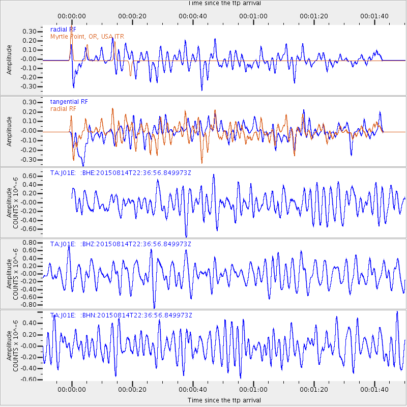
J01E Myrtle Point, OR, USA - Earthquake Result Viewer
*The percent match for this event was below the threshold and hence no stack was calculated.
| Earthquake location: |
Mariana Islands |
| Earthquake latitude/longitude: |
14.0/144.9 |
| Earthquake time(UTC): |
2015/08/14 (226) 22:25:27 GMT |
| Earthquake Depth: |
150 km |
| Earthquake Magnitude: |
4.7 mb |
| Earthquake Catalog/Contributor: |
ISC/ISC |
|
| Network: |
TA USArray Transportable Network (new EarthScope stations) |
| Station: |
J01E Myrtle Point, OR, USA |
| Lat/Lon: |
43.16 N/123.93 W |
| Elevation: |
128 m |
|
| Distance: |
81.4 deg |
| Az: |
47.717 deg |
| Baz: |
281.017 deg |
| Ray Param: |
$rayparam |
*The percent match for this event was below the threshold and hence was not used in the summary stack. |
|
| Radial Match: |
59.91101 % |
| Radial Bump: |
400 |
| Transverse Match: |
40.586582 % |
| Transverse Bump: |
400 |
| SOD ConfigId: |
7422571 |
| Insert Time: |
2019-04-20 10:34:42.588 +0000 |
| GWidth: |
2.5 |
| Max Bumps: |
400 |
| Tol: |
0.001 |
|
Signal To Noise
| Channel | StoN | STA | LTA |
| TA:J01E: :BHZ:20150814T22:36:56.849973Z | 1.3944278 | 3.0392914E-7 | 2.1795975E-7 |
| TA:J01E: :BHN:20150814T22:36:56.849973Z | 0.57165366 | 1.7912583E-7 | 3.133468E-7 |
| TA:J01E: :BHE:20150814T22:36:56.849973Z | 1.2860049 | 1.9568127E-7 | 1.5216214E-7 |
| Arrivals |
| Ps | |
| PpPs | |
| PsPs/PpSs | |


