You are here: Home > Network List > IU - Global Seismograph Network (GSN - IRIS/USGS) Stations List
> Station CCM Cathedral Cave, Missouri, USA > Earthquake Result Viewer
CCM Cathedral Cave, Missouri, USA - Earthquake Result Viewer

| Earthquake location: |
Near East Coast Of Kamchatka |
| Earthquake latitude/longitude: |
51.2/157.8 |
| Earthquake time(UTC): |
1993/06/08 (159) 13:03:37 GMT |
| Earthquake Depth: |
81 km |
| Earthquake Magnitude: |
6.4 MB, 7.3 MS |
| Earthquake Catalog/Contributor: |
WHDF/NEIC |
|
| Network: |
IU Global Seismograph Network (GSN - IRIS/USGS) |
| Station: |
CCM Cathedral Cave, Missouri, USA |
| Lat/Lon: |
38.06 N/91.24 W |
| Elevation: |
222 m |
|
| Distance: |
72.5 deg |
| Az: |
50.623 deg |
| Baz: |
321.989 deg |
| Ray Param: |
0.053407732 |
| Estimated Moho Depth: |
37.25 km |
| Estimated Crust Vp/Vs: |
2.02 |
| Assumed Crust Vp: |
6.498 km/s |
| Estimated Crust Vs: |
3.213 km/s |
| Estimated Crust Poisson's Ratio: |
0.34 |
|
| Radial Match: |
98.26543 % |
| Radial Bump: |
274 |
| Transverse Match: |
91.9177 % |
| Transverse Bump: |
400 |
| SOD ConfigId: |
16938 |
| Insert Time: |
2010-03-04 15:42:21.849 +0000 |
| GWidth: |
2.5 |
| Max Bumps: |
400 |
| Tol: |
0.001 |
|
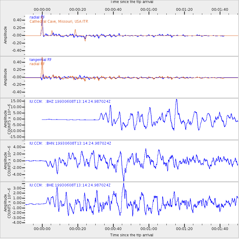
Signal To Noise
| Channel | StoN | STA | LTA |
| IU:CCM: :BHN:19930608T13:14:24.987024Z | 7.3444204 | 6.4371403E-7 | 8.764667E-8 |
| IU:CCM: :BHE:19930608T13:14:24.987024Z | 5.5815 | 4.739468E-7 | 8.491388E-8 |
| IU:CCM: :BHZ:19930608T13:14:24.987024Z | 15.313259 | 2.1828098E-6 | 1.4254378E-7 |
| Arrivals |
| Ps | 6.0 SECOND |
| PpPs | 17 SECOND |
| PsPs/PpSs | 23 SECOND |


