You are here: Home > Network List > IU - Global Seismograph Network (GSN - IRIS/USGS) Stations List
> Station CCM Cathedral Cave, Missouri, USA > Earthquake Result Viewer
CCM Cathedral Cave, Missouri, USA - Earthquake Result Viewer
| Earthquake location: |
Santiago Del Estero Prov., Arg. |
| Earthquake latitude/longitude: |
-26.7/-63.4 |
| Earthquake time(UTC): |
1994/08/19 (231) 10:02:51 GMT |
| Earthquake Depth: |
565 km |
| Earthquake Magnitude: |
6.4 MB, 6.5 UNKNOWN, 6.5 MW |
| Earthquake Catalog/Contributor: |
WHDF/NEIC |
|
| Network: |
IU Global Seismograph Network (GSN - IRIS/USGS) |
| Station: |
CCM Cathedral Cave, Missouri, USA |
| Lat/Lon: |
38.06 N/91.24 W |
| Elevation: |
222 m |
|
| Distance: |
69.5 deg |
| Az: |
336.796 deg |
| Baz: |
153.47 deg |
| Ray Param: |
0.053666737 |
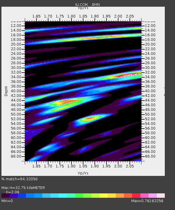
| Estimated Moho Depth: |
32.75 km |
| Estimated Crust Vp/Vs: |
2.06 |
| Assumed Crust Vp: |
6.498 km/s |
| Estimated Crust Vs: |
3.154 km/s |
| Estimated Crust Poisson's Ratio: |
0.35 |
|
| Radial Match: |
94.32058 % |
| Radial Bump: |
347 |
| Transverse Match: |
84.491776 % |
| Transverse Bump: |
400 |
| SOD ConfigId: |
16938 |
| Insert Time: |
2010-03-04 15:42:42.718 +0000 |
| GWidth: |
2.5 |
| Max Bumps: |
400 |
| Tol: |
0.001 |
|

Signal To Noise
| Channel | StoN | STA | LTA |
| IU:CCM: :BHN:19940819T10:12:33.028027Z | 37.14128 | 1.6415369E-6 | 4.41971E-8 |
| IU:CCM: :BHE:19940819T10:12:33.028027Z | 20.735931 | 7.741588E-7 | 3.733417E-8 |
| IU:CCM: :BHZ:19940819T10:12:33.028027Z | 58.28671 | 4.4301623E-6 | 7.600639E-8 |
| Arrivals |
| Ps | 5.5 SECOND |
| PpPs | 15 SECOND |
| PsPs/PpSs | 20 SECOND |


