You are here: Home > Network List > AV - Alaska Volcano Observatory Stations List
> Station MAPS Pakushin Southeast, Makushin Volcano, Alaska > Earthquake Result Viewer
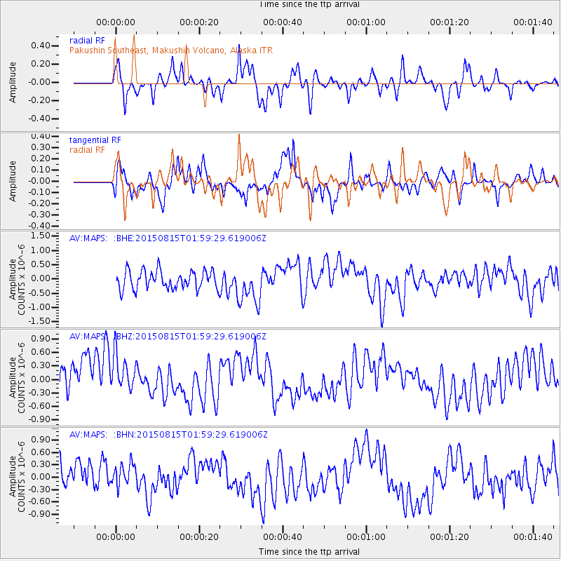
MAPS Pakushin Southeast, Makushin Volcano, Alaska - Earthquake Result Viewer
*The percent match for this event was below the threshold and hence no stack was calculated.
| Earthquake location: |
Kuril Islands |
| Earthquake latitude/longitude: |
44.2/148.1 |
| Earthquake time(UTC): |
2015/08/15 (227) 01:53:55 GMT |
| Earthquake Depth: |
100 km |
| Earthquake Magnitude: |
3.6 mb |
| Earthquake Catalog/Contributor: |
ISC/ISC |
|
| Network: |
AV Alaska Volcano Observatory |
| Station: |
MAPS Pakushin Southeast, Makushin Volcano, Alaska |
| Lat/Lon: |
53.81 N/166.94 W |
| Elevation: |
333 m |
|
| Distance: |
30.6 deg |
| Az: |
55.547 deg |
| Baz: |
270.276 deg |
| Ray Param: |
$rayparam |
*The percent match for this event was below the threshold and hence was not used in the summary stack. |
|
| Radial Match: |
57.22356 % |
| Radial Bump: |
400 |
| Transverse Match: |
61.13527 % |
| Transverse Bump: |
400 |
| SOD ConfigId: |
7422571 |
| Insert Time: |
2019-04-20 10:43:28.712 +0000 |
| GWidth: |
2.5 |
| Max Bumps: |
400 |
| Tol: |
0.001 |
|
Signal To Noise
| Channel | StoN | STA | LTA |
| AV:MAPS: :BHZ:20150815T01:59:29.619006Z | 1.280677 | 5.6355856E-7 | 4.4004736E-7 |
| AV:MAPS: :BHN:20150815T01:59:29.619006Z | 1.0785087 | 3.334305E-7 | 3.0915885E-7 |
| AV:MAPS: :BHE:20150815T01:59:29.619006Z | 2.0711997 | 6.6389157E-7 | 3.2053478E-7 |
| Arrivals |
| Ps | |
| PpPs | |
| PsPs/PpSs | |


