You are here: Home > Network List > IU - Global Seismograph Network (GSN - IRIS/USGS) Stations List
> Station CCM Cathedral Cave, Missouri, USA > Earthquake Result Viewer
CCM Cathedral Cave, Missouri, USA - Earthquake Result Viewer
| Earthquake location: |
Colombia |
| Earthquake latitude/longitude: |
2.9/-76.1 |
| Earthquake time(UTC): |
1994/06/06 (157) 20:47:39 GMT |
| Earthquake Depth: |
9.0 km |
| Earthquake Magnitude: |
6.4 MB, 6.4 MS, 6.3 UNKNOWN, 6.8 MW |
| Earthquake Catalog/Contributor: |
WHDF/NEIC |
|
| Network: |
IU Global Seismograph Network (GSN - IRIS/USGS) |
| Station: |
CCM Cathedral Cave, Missouri, USA |
| Lat/Lon: |
38.06 N/91.24 W |
| Elevation: |
222 m |
|
| Distance: |
37.6 deg |
| Az: |
340.251 deg |
| Baz: |
154.691 deg |
| Ray Param: |
0.07602633 |
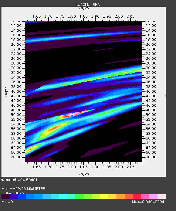
| Estimated Moho Depth: |
49.25 km |
| Estimated Crust Vp/Vs: |
1.80 |
| Assumed Crust Vp: |
6.498 km/s |
| Estimated Crust Vs: |
3.605 km/s |
| Estimated Crust Poisson's Ratio: |
0.28 |
|
| Radial Match: |
94.58481 % |
| Radial Bump: |
214 |
| Transverse Match: |
69.62201 % |
| Transverse Bump: |
400 |
| SOD ConfigId: |
16938 |
| Insert Time: |
2010-03-04 15:43:22.231 +0000 |
| GWidth: |
2.5 |
| Max Bumps: |
400 |
| Tol: |
0.001 |
|

Signal To Noise
| Channel | StoN | STA | LTA |
| IU:CCM: :BHN:19940606T20:54:24.198987Z | 27.915918 | 1.3488198E-6 | 4.8317226E-8 |
| IU:CCM: :BHE:19940606T20:54:24.198987Z | 19.515722 | 5.327494E-7 | 2.7298473E-8 |
| IU:CCM: :BHZ:19940606T20:54:24.198987Z | 35.039253 | 2.5807137E-6 | 7.3652075E-8 |
| Arrivals |
| Ps | 6.5 SECOND |
| PpPs | 20 SECOND |
| PsPs/PpSs | 26 SECOND |


