You are here: Home > Network List > IU - Global Seismograph Network (GSN - IRIS/USGS) Stations List
> Station CCM Cathedral Cave, Missouri, USA > Earthquake Result Viewer
CCM Cathedral Cave, Missouri, USA - Earthquake Result Viewer

| Earthquake location: |
Near Coast Of Northern Chile |
| Earthquake latitude/longitude: |
-23.4/-70.3 |
| Earthquake time(UTC): |
1995/07/30 (211) 05:11:23 GMT |
| Earthquake Depth: |
47 km |
| Earthquake Magnitude: |
6.6 MB, 7.3 MS, 7.2 UNKNOWN, 8.1 MW |
| Earthquake Catalog/Contributor: |
WHDF/NEIC |
|
| Network: |
IU Global Seismograph Network (GSN - IRIS/USGS) |
| Station: |
CCM Cathedral Cave, Missouri, USA |
| Lat/Lon: |
38.06 N/91.24 W |
| Elevation: |
222 m |
|
| Distance: |
64.2 deg |
| Az: |
341.741 deg |
| Baz: |
158.609 deg |
| Ray Param: |
0.05899046 |
| Estimated Moho Depth: |
45.25 km |
| Estimated Crust Vp/Vs: |
1.76 |
| Assumed Crust Vp: |
6.498 km/s |
| Estimated Crust Vs: |
3.697 km/s |
| Estimated Crust Poisson's Ratio: |
0.26 |
|
| Radial Match: |
98.77411 % |
| Radial Bump: |
265 |
| Transverse Match: |
90.52868 % |
| Transverse Bump: |
400 |
| SOD ConfigId: |
6273 |
| Insert Time: |
2010-03-04 15:43:31.935 +0000 |
| GWidth: |
2.5 |
| Max Bumps: |
400 |
| Tol: |
0.001 |
|
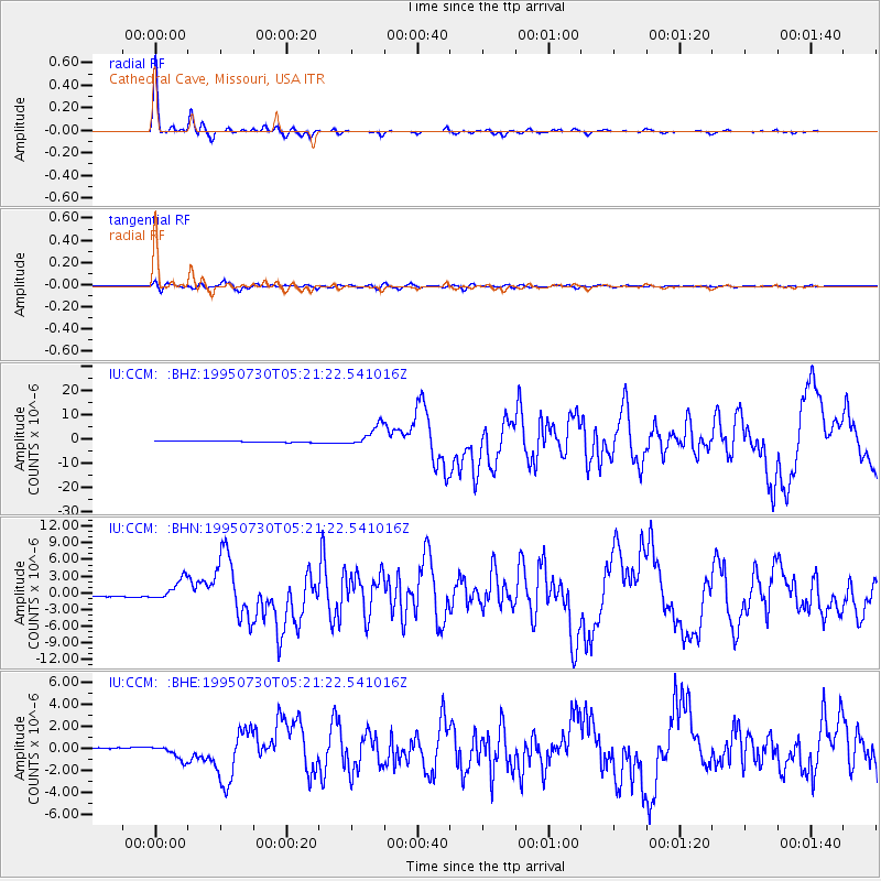
Signal To Noise
| Channel | StoN | STA | LTA |
| IU:CCM: :BHN:19950730T05:21:22.541016Z | 10.686556 | 1.830062E-6 | 1.71249E-7 |
| IU:CCM: :BHE:19950730T05:21:22.541016Z | 8.08636 | 6.378391E-7 | 7.8878394E-8 |
| IU:CCM: :BHZ:19950730T05:21:22.541016Z | 15.275183 | 4.2649326E-6 | 2.7920663E-7 |
| Arrivals |
| Ps | 5.5 SECOND |
| PpPs | 18 SECOND |
| PsPs/PpSs | 24 SECOND |


