You are here: Home > Network List > TA - USArray Transportable Network (new EarthScope stations) Stations List
> Station I23K Minto, Yukon-Koyukuk, AK, USA > Earthquake Result Viewer
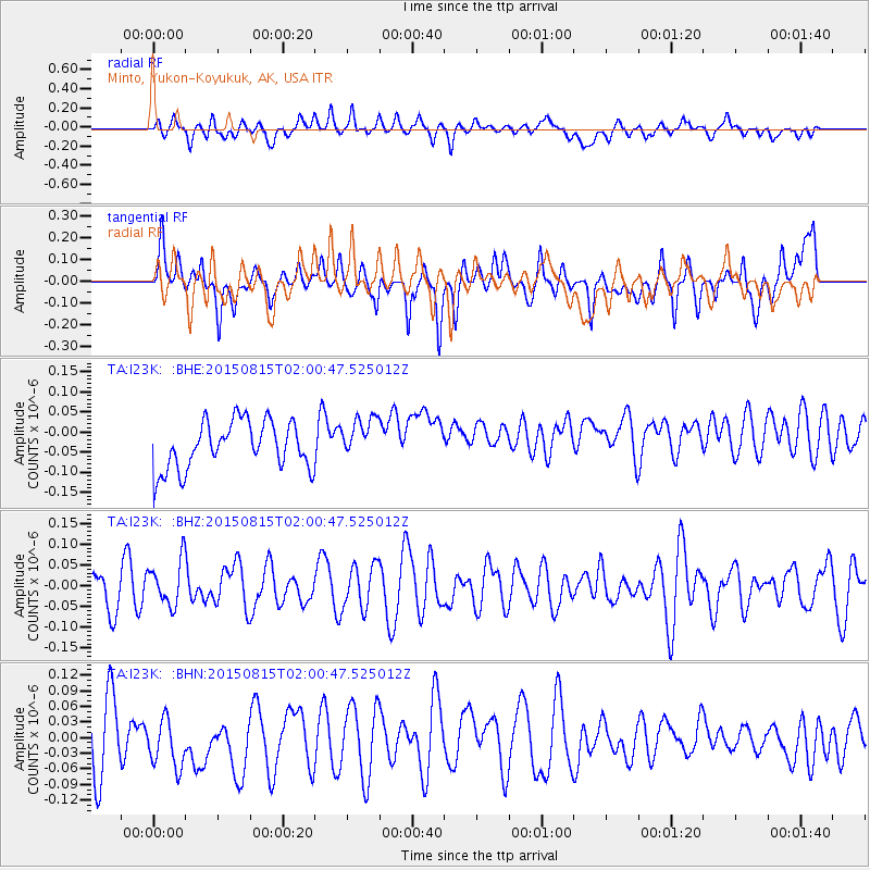
I23K Minto, Yukon-Koyukuk, AK, USA - Earthquake Result Viewer
*The percent match for this event was below the threshold and hence no stack was calculated.
| Earthquake location: |
Kuril Islands |
| Earthquake latitude/longitude: |
44.2/148.1 |
| Earthquake time(UTC): |
2015/08/15 (227) 01:53:55 GMT |
| Earthquake Depth: |
100 km |
| Earthquake Magnitude: |
3.6 mb |
| Earthquake Catalog/Contributor: |
ISC/ISC |
|
| Network: |
TA USArray Transportable Network (new EarthScope stations) |
| Station: |
I23K Minto, Yukon-Koyukuk, AK, USA |
| Lat/Lon: |
65.15 N/149.36 W |
| Elevation: |
149 m |
|
| Distance: |
39.7 deg |
| Az: |
35.984 deg |
| Baz: |
269.394 deg |
| Ray Param: |
$rayparam |
*The percent match for this event was below the threshold and hence was not used in the summary stack. |
|
| Radial Match: |
30.359386 % |
| Radial Bump: |
400 |
| Transverse Match: |
43.66189 % |
| Transverse Bump: |
400 |
| SOD ConfigId: |
7422571 |
| Insert Time: |
2019-04-20 10:48:41.011 +0000 |
| GWidth: |
2.5 |
| Max Bumps: |
400 |
| Tol: |
0.001 |
|
Signal To Noise
| Channel | StoN | STA | LTA |
| TA:I23K: :BHZ:20150815T02:00:47.525012Z | 0.952749 | 5.390298E-8 | 5.6576262E-8 |
| TA:I23K: :BHN:20150815T02:00:47.525012Z | 1.0745736 | 5.812706E-8 | 5.409314E-8 |
| TA:I23K: :BHE:20150815T02:00:47.525012Z | 0.8943265 | 5.254269E-8 | 5.8751127E-8 |
| Arrivals |
| Ps | |
| PpPs | |
| PsPs/PpSs | |


