You are here: Home > Network List > IU - Global Seismograph Network (GSN - IRIS/USGS) Stations List
> Station CCM Cathedral Cave, Missouri, USA > Earthquake Result Viewer
CCM Cathedral Cave, Missouri, USA - Earthquake Result Viewer

| Earthquake location: |
Greece |
| Earthquake latitude/longitude: |
38.4/22.3 |
| Earthquake time(UTC): |
1995/06/15 (166) 00:15:48 GMT |
| Earthquake Depth: |
14 km |
| Earthquake Magnitude: |
6.0 MB, 6.5 MS, 6.5 UNKNOWN, 5.7 ML |
| Earthquake Catalog/Contributor: |
WHDF/NEIC |
|
| Network: |
IU Global Seismograph Network (GSN - IRIS/USGS) |
| Station: |
CCM Cathedral Cave, Missouri, USA |
| Lat/Lon: |
38.06 N/91.24 W |
| Elevation: |
222 m |
|
| Distance: |
82.4 deg |
| Az: |
313.09 deg |
| Baz: |
46.623 deg |
| Ray Param: |
0.046907175 |
| Estimated Moho Depth: |
36.5 km |
| Estimated Crust Vp/Vs: |
1.91 |
| Assumed Crust Vp: |
6.498 km/s |
| Estimated Crust Vs: |
3.397 km/s |
| Estimated Crust Poisson's Ratio: |
0.31 |
|
| Radial Match: |
97.135 % |
| Radial Bump: |
330 |
| Transverse Match: |
82.916145 % |
| Transverse Bump: |
400 |
| SOD ConfigId: |
6273 |
| Insert Time: |
2010-03-04 15:43:38.245 +0000 |
| GWidth: |
2.5 |
| Max Bumps: |
400 |
| Tol: |
0.001 |
|
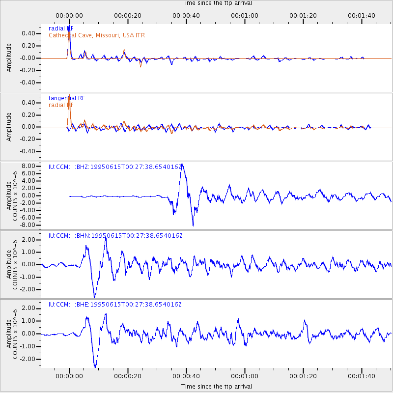
Signal To Noise
| Channel | StoN | STA | LTA |
| IU:CCM: :BHN:19950615T00:27:38.654016Z | 1.7904367 | 2.0236911E-7 | 1.1302779E-7 |
| IU:CCM: :BHE:19950615T00:27:38.654016Z | 2.308055 | 1.6989205E-7 | 7.360832E-8 |
| IU:CCM: :BHZ:19950615T00:27:38.654016Z | 6.5261707 | 6.4592876E-7 | 9.897516E-8 |
| Arrivals |
| Ps | 5.3 SECOND |
| PpPs | 16 SECOND |
| PsPs/PpSs | 21 SECOND |


