You are here: Home > Network List > IU - Global Seismograph Network (GSN - IRIS/USGS) Stations List
> Station CCM Cathedral Cave, Missouri, USA > Earthquake Result Viewer
CCM Cathedral Cave, Missouri, USA - Earthquake Result Viewer
| Earthquake location: |
Near East Coast Of Honshu, Japan |
| Earthquake latitude/longitude: |
40.2/142.2 |
| Earthquake time(UTC): |
1995/01/06 (006) 22:37:37 GMT |
| Earthquake Depth: |
57 km |
| Earthquake Magnitude: |
6.7 MB, 6.6 UNKNOWN, 7.0 MW |
| Earthquake Catalog/Contributor: |
WHDF/NEIC |
|
| Network: |
IU Global Seismograph Network (GSN - IRIS/USGS) |
| Station: |
CCM Cathedral Cave, Missouri, USA |
| Lat/Lon: |
38.06 N/91.24 W |
| Elevation: |
222 m |
|
| Distance: |
88.0 deg |
| Az: |
39.41 deg |
| Baz: |
321.995 deg |
| Ray Param: |
0.04282642 |
| Estimated Moho Depth: |
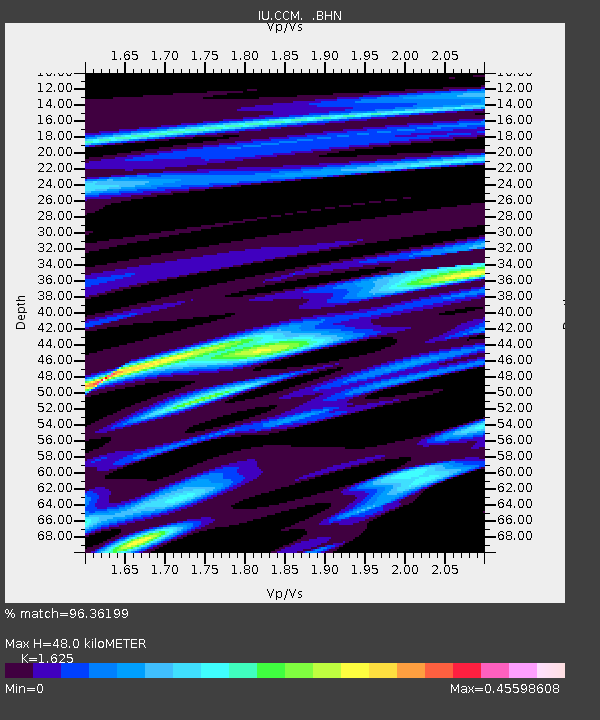
48.0 km |
| Estimated Crust Vp/Vs: |
1.62 |
| Assumed Crust Vp: |
6.498 km/s |
| Estimated Crust Vs: |
3.998 km/s |
| Estimated Crust Poisson's Ratio: |
0.20 |
|
| Radial Match: |
96.36199 % |
| Radial Bump: |
290 |
| Transverse Match: |
87.769394 % |
| Transverse Bump: |
400 |
| SOD ConfigId: |
6273 |
| Insert Time: |
2010-03-04 15:43:55.983 +0000 |
| GWidth: |
2.5 |
| Max Bumps: |
400 |
| Tol: |
0.001 |
|

Signal To Noise
| Channel | StoN | STA | LTA |
| IU:CCM: :BHN:19950106T22:49:50.529028Z | 5.4414067 | 9.922176E-7 | 1.8234579E-7 |
| IU:CCM: :BHE:19950106T22:49:50.529028Z | 6.3035994 | 9.874908E-7 | 1.5665508E-7 |
| IU:CCM: :BHZ:19950106T22:49:50.529028Z | 27.388485 | 4.055754E-6 | 1.4808245E-7 |
| Arrivals |
| Ps | 4.7 SECOND |
| PpPs | 19 SECOND |
| PsPs/PpSs | 24 SECOND |


