You are here: Home > Network List > AK - Alaska Regional Network Stations List
> Station COLD Coldfoot Broadband > Earthquake Result Viewer
COLD Coldfoot Broadband - Earthquake Result Viewer
| Earthquake location: |
Solomon Islands |
| Earthquake latitude/longitude: |
-10.9/163.9 |
| Earthquake time(UTC): |
2015/08/15 (227) 07:47:06 GMT |
| Earthquake Depth: |
6.4 km |
| Earthquake Magnitude: |
6.6 MWP, 6.6 MI |
| Earthquake Catalog/Contributor: |
NEIC PDE/NEIC COMCAT |
|
| Network: |
AK Alaska Regional Network |
| Station: |
COLD Coldfoot Broadband |
| Lat/Lon: |
67.23 N/150.20 W |
| Elevation: |
377 m |
|
| Distance: |
84.7 deg |
| Az: |
16.313 deg |
| Baz: |
225.125 deg |
| Ray Param: |
0.04532111 |
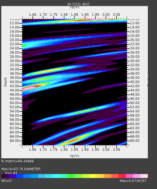
| Estimated Moho Depth: |
42.75 km |
| Estimated Crust Vp/Vs: |
1.63 |
| Assumed Crust Vp: |
6.577 km/s |
| Estimated Crust Vs: |
4.035 km/s |
| Estimated Crust Poisson's Ratio: |
0.20 |
|
| Radial Match: |
94.44666 % |
| Radial Bump: |
347 |
| Transverse Match: |
85.681885 % |
| Transverse Bump: |
400 |
| SOD ConfigId: |
7422571 |
| Insert Time: |
2019-04-20 10:52:27.269 +0000 |
| GWidth: |
2.5 |
| Max Bumps: |
400 |
| Tol: |
0.001 |
|
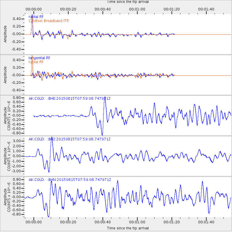
Signal To Noise
| Channel | StoN | STA | LTA |
| AK:COLD: :BHZ:20150815T07:59:08.747971Z | 17.01255 | 6.7052275E-7 | 3.9413415E-8 |
| AK:COLD: :BHN:20150815T07:59:08.747971Z | 4.471715 | 1.7257085E-7 | 3.8591647E-8 |
| AK:COLD: :BHE:20150815T07:59:08.747971Z | 9.026403 | 1.8185617E-7 | 2.0147134E-8 |
| Arrivals |
| Ps | 4.2 SECOND |
| PpPs | 17 SECOND |
| PsPs/PpSs | 21 SECOND |


