You are here: Home > Network List > AK - Alaska Regional Network Stations List
> Station NIKH Nikolski High Hill > Earthquake Result Viewer
NIKH Nikolski High Hill - Earthquake Result Viewer
| Earthquake location: |
Solomon Islands |
| Earthquake latitude/longitude: |
-10.9/163.9 |
| Earthquake time(UTC): |
2015/08/15 (227) 07:47:06 GMT |
| Earthquake Depth: |
6.4 km |
| Earthquake Magnitude: |
6.6 MWP, 6.6 MI |
| Earthquake Catalog/Contributor: |
NEIC PDE/NEIC COMCAT |
|
| Network: |
AK Alaska Regional Network |
| Station: |
NIKH Nikolski High Hill |
| Lat/Lon: |
52.97 N/168.85 W |
| Elevation: |
199 m |
|
| Distance: |
67.8 deg |
| Az: |
17.418 deg |
| Baz: |
209.088 deg |
| Ray Param: |
0.056745768 |
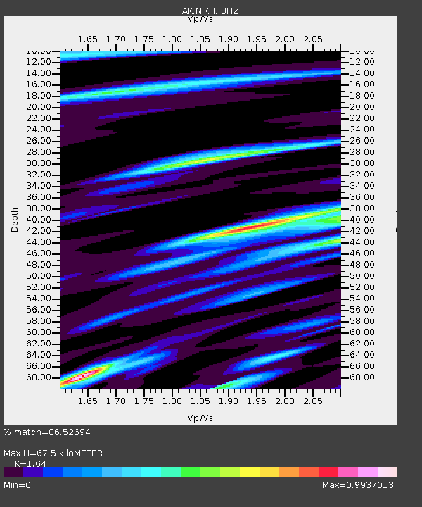
| Estimated Moho Depth: |
67.5 km |
| Estimated Crust Vp/Vs: |
1.64 |
| Assumed Crust Vp: |
5.88 km/s |
| Estimated Crust Vs: |
3.586 km/s |
| Estimated Crust Poisson's Ratio: |
0.20 |
|
| Radial Match: |
86.52694 % |
| Radial Bump: |
400 |
| Transverse Match: |
67.52736 % |
| Transverse Bump: |
400 |
| SOD ConfigId: |
7422571 |
| Insert Time: |
2019-04-20 10:53:02.819 +0000 |
| GWidth: |
2.5 |
| Max Bumps: |
400 |
| Tol: |
0.001 |
|

Signal To Noise
| Channel | StoN | STA | LTA |
| AK:NIKH: :BHZ:20150815T07:57:33.087998Z | 5.4882603 | 1.7206355E-6 | 3.13512E-7 |
| AK:NIKH: :BHN:20150815T07:57:33.087998Z | 2.1860049 | 7.5190064E-7 | 3.439611E-7 |
| AK:NIKH: :BHE:20150815T07:57:33.087998Z | 1.6971489 | 6.6509944E-7 | 3.918922E-7 |
| Arrivals |
| Ps | 7.6 SECOND |
| PpPs | 29 SECOND |
| PsPs/PpSs | 37 SECOND |


