You are here: Home > Network List > AK - Alaska Regional Network Stations List
> Station SSP Sunshine Point, AK, USA > Earthquake Result Viewer
SSP Sunshine Point, AK, USA - Earthquake Result Viewer
| Earthquake location: |
Solomon Islands |
| Earthquake latitude/longitude: |
-10.9/163.9 |
| Earthquake time(UTC): |
2015/08/15 (227) 07:47:06 GMT |
| Earthquake Depth: |
6.4 km |
| Earthquake Magnitude: |
6.6 MWP, 6.6 MI |
| Earthquake Catalog/Contributor: |
NEIC PDE/NEIC COMCAT |
|
| Network: |
AK Alaska Regional Network |
| Station: |
SSP Sunshine Point, AK, USA |
| Lat/Lon: |
60.18 N/142.84 W |
| Elevation: |
474 m |
|
| Distance: |
82.5 deg |
| Az: |
23.836 deg |
| Baz: |
232.574 deg |
| Ray Param: |
0.046857264 |
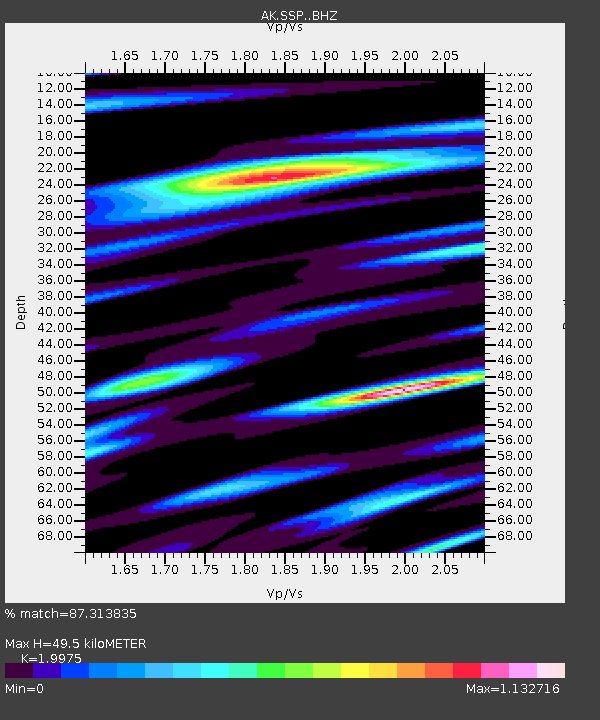
| Estimated Moho Depth: |
49.5 km |
| Estimated Crust Vp/Vs: |
2.00 |
| Assumed Crust Vp: |
6.566 km/s |
| Estimated Crust Vs: |
3.287 km/s |
| Estimated Crust Poisson's Ratio: |
0.33 |
|
| Radial Match: |
87.313835 % |
| Radial Bump: |
400 |
| Transverse Match: |
87.53961 % |
| Transverse Bump: |
400 |
| SOD ConfigId: |
7422571 |
| Insert Time: |
2019-04-20 10:53:22.201 +0000 |
| GWidth: |
2.5 |
| Max Bumps: |
400 |
| Tol: |
0.001 |
|

Signal To Noise
| Channel | StoN | STA | LTA |
| AK:SSP: :BHZ:20150815T07:58:57.627976Z | 11.080362 | 1.328044E-6 | 1.1985564E-7 |
| AK:SSP: :BHN:20150815T07:58:57.627976Z | 4.8061514 | 5.174754E-7 | 1.076694E-7 |
| AK:SSP: :BHE:20150815T07:58:57.627976Z | 2.7652724 | 2.7778466E-7 | 1.0045473E-7 |
| Arrivals |
| Ps | 7.7 SECOND |
| PpPs | 22 SECOND |
| PsPs/PpSs | 30 SECOND |


