You are here: Home > Network List > AK - Alaska Regional Network Stations List
> Station TNA Tin City Broadband > Earthquake Result Viewer
TNA Tin City Broadband - Earthquake Result Viewer

| Earthquake location: |
Solomon Islands |
| Earthquake latitude/longitude: |
-10.9/163.9 |
| Earthquake time(UTC): |
2015/08/15 (227) 07:47:06 GMT |
| Earthquake Depth: |
6.4 km |
| Earthquake Magnitude: |
6.6 MWP, 6.6 MI |
| Earthquake Catalog/Contributor: |
NEIC PDE/NEIC COMCAT |
|
| Network: |
AK Alaska Regional Network |
| Station: |
TNA Tin City Broadband |
| Lat/Lon: |
65.56 N/167.92 W |
| Elevation: |
74 m |
|
| Distance: |
79.1 deg |
| Az: |
11.549 deg |
| Baz: |
208.207 deg |
| Ray Param: |
0.04920374 |
| Estimated Moho Depth: |
30.5 km |
| Estimated Crust Vp/Vs: |
1.81 |
| Assumed Crust Vp: |
6.307 km/s |
| Estimated Crust Vs: |
3.494 km/s |
| Estimated Crust Poisson's Ratio: |
0.28 |
|
| Radial Match: |
94.18073 % |
| Radial Bump: |
334 |
| Transverse Match: |
73.436745 % |
| Transverse Bump: |
400 |
| SOD ConfigId: |
7422571 |
| Insert Time: |
2019-04-20 10:53:26.218 +0000 |
| GWidth: |
2.5 |
| Max Bumps: |
400 |
| Tol: |
0.001 |
|
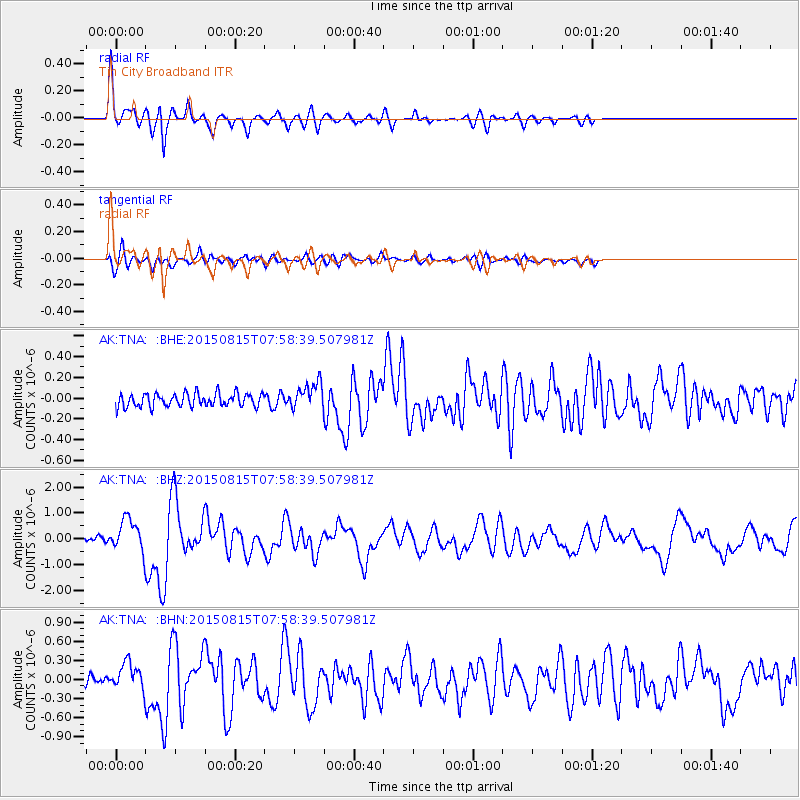
Signal To Noise
| Channel | StoN | STA | LTA |
| AK:TNA: :BHZ:20150815T07:58:39.507981Z | 7.1370215 | 6.3634633E-7 | 8.9161325E-8 |
| AK:TNA: :BHN:20150815T07:58:39.507981Z | 2.291542 | 2.1156985E-7 | 9.232641E-8 |
| AK:TNA: :BHE:20150815T07:58:39.507981Z | 2.4248815 | 1.4943127E-7 | 6.1624156E-8 |
| Arrivals |
| Ps | 4.0 SECOND |
| PpPs | 13 SECOND |
| PsPs/PpSs | 17 SECOND |


