You are here: Home > Network List > US - United States National Seismic Network Stations List
> Station HAWA Hanford, Washington, USA > Earthquake Result Viewer
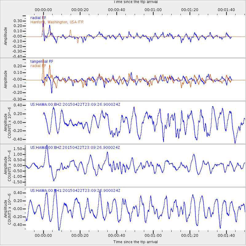
HAWA Hanford, Washington, USA - Earthquake Result Viewer
*The percent match for this event was below the threshold and hence no stack was calculated.
| Earthquake location: |
Santa Cruz Islands |
| Earthquake latitude/longitude: |
-12.0/166.4 |
| Earthquake time(UTC): |
2015/04/22 (112) 22:57:16 GMT |
| Earthquake Depth: |
74 km |
| Earthquake Magnitude: |
5.8 MB |
| Earthquake Catalog/Contributor: |
NEIC PDE/NEIC ALERT |
|
| Network: |
US United States National Seismic Network |
| Station: |
HAWA Hanford, Washington, USA |
| Lat/Lon: |
46.39 N/119.53 W |
| Elevation: |
364 m |
|
| Distance: |
87.9 deg |
| Az: |
41.766 deg |
| Baz: |
250.315 deg |
| Ray Param: |
$rayparam |
*The percent match for this event was below the threshold and hence was not used in the summary stack. |
|
| Radial Match: |
75.619255 % |
| Radial Bump: |
400 |
| Transverse Match: |
54.12731 % |
| Transverse Bump: |
377 |
| SOD ConfigId: |
872571 |
| Insert Time: |
2015-05-06 23:29:21.808 +0000 |
| GWidth: |
2.5 |
| Max Bumps: |
400 |
| Tol: |
0.001 |
|
Signal To Noise
| Channel | StoN | STA | LTA |
| US:HAWA:00:BHZ:20150422T23:09:26.900024Z | 3.3009317 | 8.6147156E-7 | 2.609783E-7 |
| US:HAWA:00:BH1:20150422T23:09:26.900024Z | 1.6611472 | 2.476224E-7 | 1.490671E-7 |
| US:HAWA:00:BH2:20150422T23:09:26.900024Z | 1.119402 | 1.5978407E-7 | 1.4274056E-7 |
| Arrivals |
| Ps | |
| PpPs | |
| PsPs/PpSs | |


