You are here: Home > Network List > CI - Caltech Regional Seismic Network Stations List
> Station EDW2 EDW2, Mojave, CA, USA > Earthquake Result Viewer
EDW2 EDW2, Mojave, CA, USA - Earthquake Result Viewer
| Earthquake location: |
Solomon Islands |
| Earthquake latitude/longitude: |
-10.9/163.9 |
| Earthquake time(UTC): |
2015/08/15 (227) 07:47:06 GMT |
| Earthquake Depth: |
6.4 km |
| Earthquake Magnitude: |
6.6 MWP, 6.6 MI |
| Earthquake Catalog/Contributor: |
NEIC PDE/NEIC COMCAT |
|
| Network: |
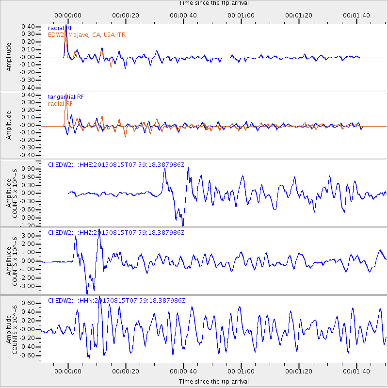
CI Caltech Regional Seismic Network |
| Station: |
EDW2 EDW2, Mojave, CA, USA |
| Lat/Lon: |
34.88 N/117.99 W |
| Elevation: |
772 m |
|
| Distance: |
86.6 deg |
| Az: |
53.703 deg |
| Baz: |
254.335 deg |
| Ray Param: |
0.043932088 |
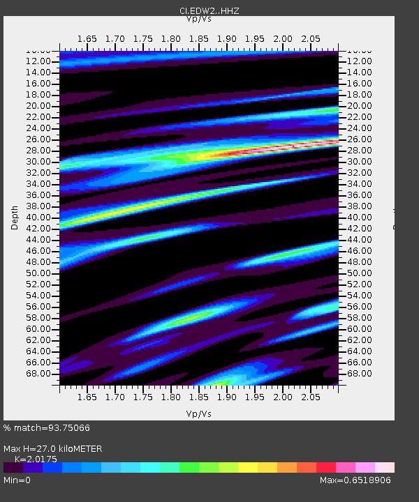
| Estimated Moho Depth: |
27.0 km |
| Estimated Crust Vp/Vs: |
2.02 |
| Assumed Crust Vp: |
6.276 km/s |
| Estimated Crust Vs: |
3.111 km/s |
| Estimated Crust Poisson's Ratio: |
0.34 |
|
| Radial Match: |
93.75066 % |
| Radial Bump: |
309 |
| Transverse Match: |
83.73028 % |
| Transverse Bump: |
396 |
| SOD ConfigId: |
7422571 |
| Insert Time: |
2019-04-20 10:55:32.044 +0000 |
| GWidth: |
2.5 |
| Max Bumps: |
400 |
| Tol: |
0.001 |
|
Signal To Noise
| Channel | StoN | STA | LTA |
| CI:EDW2: :HHZ:20150815T07:59:18.387986Z | 22.900623 | 1.0780517E-6 | 4.707521E-8 |
| CI:EDW2: :HHN:20150815T07:59:18.387986Z | 3.0269654 | 1.9017638E-7 | 6.2827404E-8 |
| CI:EDW2: :HHE:20150815T07:59:18.387986Z | 9.203067 | 3.737056E-7 | 4.0606636E-8 |
| Arrivals |
| Ps | 4.5 SECOND |
| PpPs | 13 SECOND |
| PsPs/PpSs | 17 SECOND |


