You are here: Home > Network List > NN - Western Great Basin/Eastern Sierra Nevada Stations List
> Station EMB Emerald Bay, California w84 > Earthquake Result Viewer
EMB Emerald Bay, California w84 - Earthquake Result Viewer
| Earthquake location: |
Solomon Islands |
| Earthquake latitude/longitude: |
-10.9/163.9 |
| Earthquake time(UTC): |
2015/08/15 (227) 07:47:06 GMT |
| Earthquake Depth: |
6.4 km |
| Earthquake Magnitude: |
6.6 MWP, 6.6 MI |
| Earthquake Catalog/Contributor: |
NEIC PDE/NEIC COMCAT |
|
| Network: |
NN Western Great Basin/Eastern Sierra Nevada |
| Station: |
EMB Emerald Bay, California w84 |
| Lat/Lon: |
38.97 N/120.10 W |
| Elevation: |
2134 m |
|
| Distance: |
86.1 deg |
| Az: |
49.298 deg |
| Baz: |
252.794 deg |
| Ray Param: |
0.04426524 |
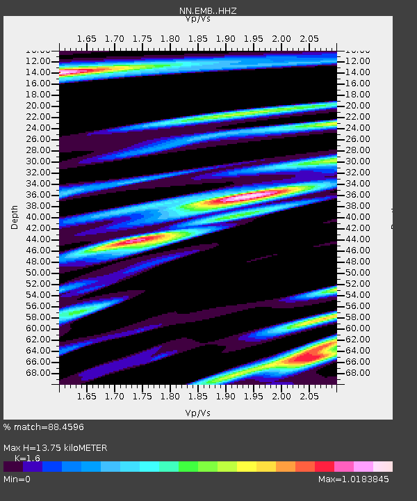
| Estimated Moho Depth: |
13.75 km |
| Estimated Crust Vp/Vs: |
1.60 |
| Assumed Crust Vp: |
6.597 km/s |
| Estimated Crust Vs: |
4.123 km/s |
| Estimated Crust Poisson's Ratio: |
0.18 |
|
| Radial Match: |
88.4596 % |
| Radial Bump: |
400 |
| Transverse Match: |
80.0166 % |
| Transverse Bump: |
400 |
| SOD ConfigId: |
7422571 |
| Insert Time: |
2019-04-20 10:58:23.881 +0000 |
| GWidth: |
2.5 |
| Max Bumps: |
400 |
| Tol: |
0.001 |
|

Signal To Noise
| Channel | StoN | STA | LTA |
| NN:EMB: :HHZ:20150815T07:59:16.108018Z | 14.829513 | 2.6873004E-5 | 1.81213E-6 |
| NN:EMB: :HHN:20150815T07:59:16.108018Z | 1.8544863 | 4.0057084E-6 | 2.1600097E-6 |
| NN:EMB: :HHE:20150815T07:59:16.108018Z | 4.146512 | 9.460544E-6 | 2.2815668E-6 |
| Arrivals |
| Ps | 1.3 SECOND |
| PpPs | 5.3 SECOND |
| PsPs/PpSs | 6.6 SECOND |


