You are here: Home > Network List > PS - Pacific21 Stations List
> Station PSI Parapat, Indonesia > Earthquake Result Viewer
PSI Parapat, Indonesia - Earthquake Result Viewer
| Earthquake location: |
Solomon Islands |
| Earthquake latitude/longitude: |
-10.9/163.9 |
| Earthquake time(UTC): |
2015/08/15 (227) 07:47:06 GMT |
| Earthquake Depth: |
6.4 km |
| Earthquake Magnitude: |
6.6 MWP, 6.6 MI |
| Earthquake Catalog/Contributor: |
NEIC PDE/NEIC COMCAT |
|
| Network: |
PS Pacific21 |
| Station: |
PSI Parapat, Indonesia |
| Lat/Lon: |
2.69 N/98.92 E |
| Elevation: |
987 m |
|
| Distance: |
66.0 deg |
| Az: |
277.885 deg |
| Baz: |
103.106 deg |
| Ray Param: |
0.057904493 |
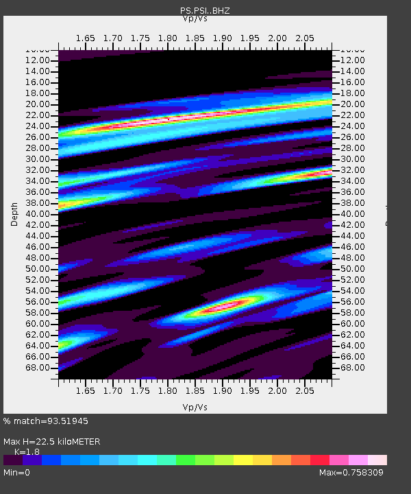
| Estimated Moho Depth: |
22.5 km |
| Estimated Crust Vp/Vs: |
1.80 |
| Assumed Crust Vp: |
6.468 km/s |
| Estimated Crust Vs: |
3.593 km/s |
| Estimated Crust Poisson's Ratio: |
0.28 |
|
| Radial Match: |
93.51945 % |
| Radial Bump: |
400 |
| Transverse Match: |
88.22613 % |
| Transverse Bump: |
400 |
| SOD ConfigId: |
7422571 |
| Insert Time: |
2019-04-20 10:58:57.758 +0000 |
| GWidth: |
2.5 |
| Max Bumps: |
400 |
| Tol: |
0.001 |
|
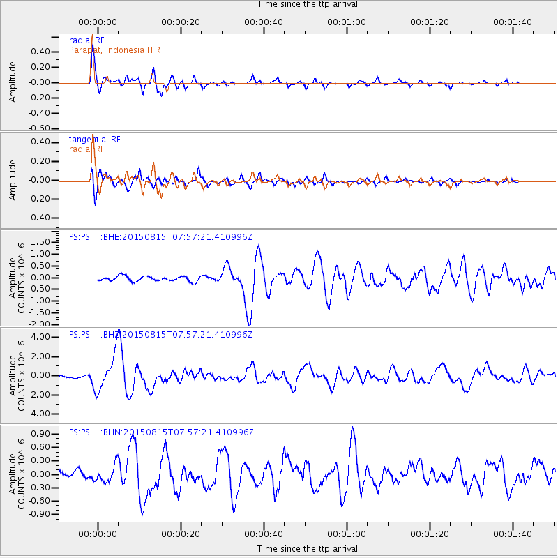
Signal To Noise
| Channel | StoN | STA | LTA |
| PS:PSI: :BHZ:20150815T07:57:21.410996Z | 17.427946 | 1.959868E-6 | 1.1245549E-7 |
| PS:PSI: :BHN:20150815T07:57:21.410996Z | 2.2608964 | 1.9570977E-7 | 8.656291E-8 |
| PS:PSI: :BHE:20150815T07:57:21.410996Z | 5.66974 | 6.410322E-7 | 1.13062015E-7 |
| Arrivals |
| Ps | 2.9 SECOND |
| PpPs | 9.4 SECOND |
| PsPs/PpSs | 12 SECOND |


